
Mapa topográfico Upper Langwith
Haga clic en el mapa para ver la altitud.
Acerca de este mapa
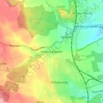
Nombre: Mapa topográfico Upper Langwith, altitud, relieve.
Altitud media: 112 m
Altitud mínima: 62 m
Altitud máxima: 171 m
Otros mapas topográficos
Haga clic en un mapa para ver su topografía, su altitud y su relieve.
Glapwell
United Kingdom > England > Derbyshire > Bolsover
Glapwell is a rural village and civil parish on the A617 road in the Bolsover District of north-east Derbyshire, The village is at the top of a steep hill at an elevation of 176m, on the western edge of the Southern Magnesian Limestone] overlooking the valley of the River Doe Lea (formerly known as the…
Altitud media: 156 m