
Mapa topográfico Chachani Volcano
Mapa interactivo
Haga clic en el mapa para ver la altitud.
Acerca de este mapa
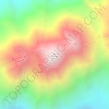
Nombre: Mapa topográfico Chachani Volcano, altitud, relieve.
Altitud media: 5.562 m
Altitud mínima: 5.032 m
Altitud máxima: 6.071 m
The volcano lies in the Andes of southern Peru, 22 kilometres (14 mi) northwest of Arequipa and north of the Arequipa Airport; the city of Arequipa is situated on the foot of Chachani and El Misti volcanoes. The road from Arequipa to Chivay runs along the southeastern foot of Chachani, and a dirt road reaches to an elevation of 5,000 metres (16,000 ft). It is considered to be one of the most easily climbed mountains between 6,000 - 7,000 m high, although acclimatization and good physical health are required to ascend it.