
Haz una donación
Equípate para tu próxima aventura:
Como asociado de Amazon, este sitio gana comisiones por las compras que califican, sin ningún costo adicional para usted.
Mapa topográfico Colebrook
Haga clic en el mapa para ver la altitud.
Haz una donación
Equípate para tu próxima aventura:
Como asociado de Amazon, este sitio gana comisiones por las compras que califican, sin ningún costo adicional para usted.
Colebrook
According to the United States Census Bureau, the town of Colebrook has a total area of 40.7 square miles (105.5 km2), of which 40.5 square miles (104.9 km2) are land and 0.2 square miles (0.5 km2) are water, comprising 0.51% of the town. The highest point in Colebrook is Van Dyck Mountain, elevation 2,760 feet (840 m), in the northeastern corner of the town. Colebrook's western view is dominated by Monadnock Mountain, elevation 3,148 ft (960 m), in Lemington. Colebrook is drained by the Mohawk River, which flows into the Connecticut River. Beaver Brook joins the Mohawk from the north in Colebrook village. The town lies almost fully within the Connecticut River watershed, with a tiny portion of the northeastern corner of town lying in the Androscoggin River watershed.
Haz una donación
Equípate para tu próxima aventura:
Como asociado de Amazon, este sitio gana comisiones por las compras que califican, sin ningún costo adicional para usted.
Acerca de este mapa
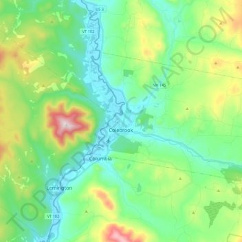
Nombre: Mapa topográfico Colebrook, altitud, relieve.
Lugar: Colebrook, Coös County, New Hampshire, 03576, United States (44.85632 -71.52279 44.94316 -71.30820)
Altitud media: 476 m
Altitud mínima: 299 m
Altitud máxima: 953 m
Haz una donación
Equípate para tu próxima aventura:
Como asociado de Amazon, este sitio gana comisiones por las compras que califican, sin ningún costo adicional para usted.
Otros mapas topográficos
Haga clic en un mapa para ver su topografía, su altitud y su relieve.
Mount Washington
United States > New Hampshire > Coos County
Mount Washington, also known as Agiocochook, is an ultra-prominent mountain in the state of New Hampshire. It is the highest peak in the Northeastern United States at 6,288.2 ft (1,916.6 m) and the most topographically prominent mountain east of the Mississippi River.
Altitud media: 1.568 m
Mount Washington
United States > New Hampshire > Coos County
Mount Washington, in New Hampshire, is the highest peak in the Northeastern United States at 6,288.2 ft (1,916.6 m) and the most topographically prominent mountain east of the Mississippi River.
Altitud media: 1.568 m
Mount Adams
United States > New Hampshire > Coos County
Mount Adams, elevation 5,793 feet (1,766 m) above sea level, is a mountain in New Hampshire, the second highest peak in the Northeast United States after its nearby neighbor, Mount Washington. Located in the northern Presidential Range, Mount Adams was named after John Adams, the second President of the United…
Altitud media: 1.379 m
Haz una donación
Equípate para tu próxima aventura:
Como asociado de Amazon, este sitio gana comisiones por las compras que califican, sin ningún costo adicional para usted.
Haz una donación
Equípate para tu próxima aventura:
Como asociado de Amazon, este sitio gana comisiones por las compras que califican, sin ningún costo adicional para usted.
Mount Washington
United States > New Hampshire > Coos County
Mount Washington is an ultra-prominent mountain in the state of New Hampshire. It is the highest peak in the Northeastern United States at 6,288.2 ft (1,916.6 m) and the most topographically prominent mountain east of the Mississippi River.
Altitud media: 1.568 m
Haz una donación
Equípate para tu próxima aventura:
Como asociado de Amazon, este sitio gana comisiones por las compras que califican, sin ningún costo adicional para usted.
Mount Washington
United States > New Hampshire > Coos County
Mount Washington, also known as Agiocochook, is an ultra-prominent mountain in the state of New Hampshire. It is the highest peak in the Northeastern United States at 6,288.2 ft (1,916.6 m) and the most topographically prominent mountain east of the Mississippi River.
Altitud media: 1.568 m
Haz una donación
Equípate para tu próxima aventura:
Como asociado de Amazon, este sitio gana comisiones por las compras que califican, sin ningún costo adicional para usted.
Haz una donación
Equípate para tu próxima aventura:
Como asociado de Amazon, este sitio gana comisiones por las compras que califican, sin ningún costo adicional para usted.