
Mapa topográfico Candon
Haga clic en el mapa para ver la altitud.
Candon
Candon City is situated in the lower central portion of the Province of Ilocos Sur. It has a "C" shape with elevations ranging from 10 – 500 ft above sea level. The city is 346 kilometres (215 mi) from Metro Manila and 61 kilometres (38 mi) from Vigan City, the provincial capital.
Acerca de este mapa
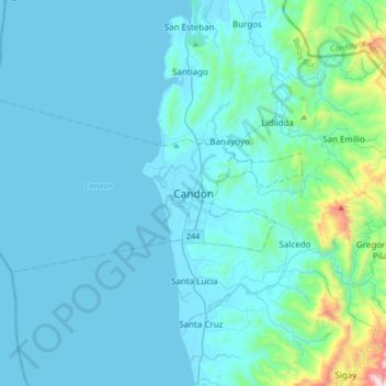
Nombre: Mapa topográfico Candon, altitud, relieve.
Lugar: Candon, Ilocos Sur, Ilocos Region, 2710, Philippines (17.03541 120.28792 17.35541 120.60792)
Altitud media: 108 m
Altitud mínima: -1 m
Altitud máxima: 1.279 m