
Haz una donación
Equípate para tu próxima aventura:
Como asociado de Amazon, este sitio gana comisiones por las compras que califican, sin ningún costo adicional para usted.
Mapa topográfico Mystic
Haga clic en el mapa para ver la altitud.
Haz una donación
Equípate para tu próxima aventura:
Como asociado de Amazon, este sitio gana comisiones por las compras que califican, sin ningún costo adicional para usted.
Acerca de este mapa
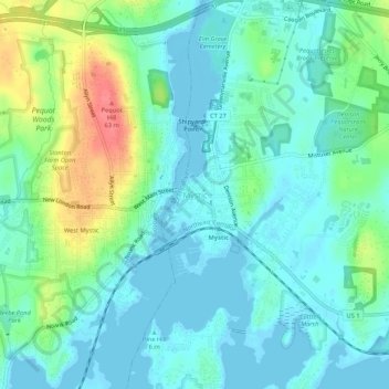
Nombre: Mapa topográfico Mystic, altitud, relieve.
Altitud media: 24 m
Altitud mínima: -2 m
Altitud máxima: 95 m
Haz una donación
Equípate para tu próxima aventura:
Como asociado de Amazon, este sitio gana comisiones por las compras que califican, sin ningún costo adicional para usted.
Otros mapas topográficos
Haga clic en un mapa para ver su topografía, su altitud y su relieve.
Mystic
United States > Connecticut > Southeastern Connecticut Planning Region > Stonington > Mystic
Altitud media: 15 m
Haz una donación
Equípate para tu próxima aventura:
Como asociado de Amazon, este sitio gana comisiones por las compras que califican, sin ningún costo adicional para usted.
East Lyme
United States > Connecticut > Southeastern Connecticut Planning Region
The topography of East Lyme consists of rolling hills and lush valleys rounded by glaciers during the last Ice Age. Hills rise to elevations of 250 to 350 feet (76 to 107 m) above sea level in the eastern and central areas of the town. The highest point in town is an unnamed hill with an elevation of 500 feet…
Altitud media: 41 m
Haz una donación
Equípate para tu próxima aventura:
Como asociado de Amazon, este sitio gana comisiones por las compras que califican, sin ningún costo adicional para usted.
Noank
United States > Connecticut > Southeastern Connecticut Planning Region > Groton > Noank
Altitud media: 15 m
Gales Ferry
United States > Connecticut > Southeastern Connecticut Planning Region > Ledyard > Gales Ferry
Altitud media: 24 m
Colchester
United States > Connecticut > Southeastern Connecticut Planning Region
Altitud media: 134 m
Haz una donación
Equípate para tu próxima aventura:
Como asociado de Amazon, este sitio gana comisiones por las compras que califican, sin ningún costo adicional para usted.
Taftville
United States > Connecticut > Southeastern Connecticut Planning Region > Norwich
Altitud media: 47 m
Haz una donación
Equípate para tu próxima aventura:
Como asociado de Amazon, este sitio gana comisiones por las compras que califican, sin ningún costo adicional para usted.
Austrailia Beach
United States > Connecticut > Southeastern Connecticut Planning Region > Mystic
Altitud media: 19 m
Old Mystic
United States > Connecticut > Southeastern Connecticut Planning Region > Groton > Old Mystic
Altitud media: 42 m
North Stonington
United States > Connecticut > Southeastern Connecticut Planning Region
Altitud media: 78 m
Haz una donación
Equípate para tu próxima aventura:
Como asociado de Amazon, este sitio gana comisiones por las compras que califican, sin ningún costo adicional para usted.
Mystic
United States > Connecticut > Southeastern Connecticut Planning Region > Stonington > Mystic
Altitud media: 15 m
East Lyme
United States > Connecticut > Southeastern Connecticut Planning Region
The topography of East Lyme consists of rolling hills and lush valleys rounded by glaciers during the last Ice Age. Hills rise to elevations of 250 to 350 feet (76 to 107 m) above sea level in the eastern and central areas of the town. The highest point in town is an unnamed hill with an elevation of 500 feet…
Altitud media: 41 m
Thames River
United States > Connecticut > Southeastern Connecticut Planning Region > Ledyard
Altitud media: 52 m
Haz una donación
Equípate para tu próxima aventura:
Como asociado de Amazon, este sitio gana comisiones por las compras que califican, sin ningún costo adicional para usted.
Austrailia Beach
United States > Connecticut > Southeastern Connecticut Planning Region > Mystic
Altitud media: 19 m
Haz una donación
Equípate para tu próxima aventura:
Como asociado de Amazon, este sitio gana comisiones por las compras que califican, sin ningún costo adicional para usted.
Taftville Reservoir #1 Dam
United States > Connecticut > Southeastern Connecticut Planning Region > Norwich
Altitud media: 75 m
Haz una donación
Equípate para tu próxima aventura:
Como asociado de Amazon, este sitio gana comisiones por las compras que califican, sin ningún costo adicional para usted.
Blue Lake
United States > Connecticut > Southeastern Connecticut Planning Region > North Stonington
Altitud media: 106 m
Thames River
United States > Connecticut > Southeastern Connecticut Planning Region > Waterford
Altitud media: 52 m
Haz una donación
Equípate para tu próxima aventura:
Como asociado de Amazon, este sitio gana comisiones por las compras que califican, sin ningún costo adicional para usted.
Austrailia Beach
United States > Connecticut > Southeastern Connecticut Planning Region > Mystic
Altitud media: 19 m
Haz una donación
Equípate para tu próxima aventura:
Como asociado de Amazon, este sitio gana comisiones por las compras que califican, sin ningún costo adicional para usted.
Austrailia Beach
United States > Connecticut > Southeastern Connecticut Planning Region > Mystic
Altitud media: 19 m
Hanover Reservoir
United States > Connecticut > Southeastern Connecticut Planning Region > Hanover
Altitud media: 91 m
Haz una donación
Equípate para tu próxima aventura:
Como asociado de Amazon, este sitio gana comisiones por las compras que califican, sin ningún costo adicional para usted.
Willimantic
United States > Connecticut > Southeastern Connecticut Planning Region > Willimantic > Windham
Altitud media: 95 m
North Stonington
United States > Connecticut > Southeastern Connecticut Planning Region
Altitud media: 73 m
Haz una donación
Equípate para tu próxima aventura:
Como asociado de Amazon, este sitio gana comisiones por las compras que califican, sin ningún costo adicional para usted.
Harkness Memorial State Park
United States > Connecticut > Southeastern Connecticut Planning Region > Waterford
Altitud media: 12 m
Haz una donación
Equípate para tu próxima aventura:
Como asociado de Amazon, este sitio gana comisiones por las compras que califican, sin ningún costo adicional para usted.