
Mapa topográfico Province of Chumbivilcas
Mapa interactivo
Haga clic en el mapa para ver la altitud.
Acerca de este mapa
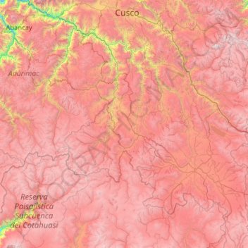
Nombre: Mapa topográfico Province of Chumbivilcas, altitud, relieve.
Lugar: Province of Chumbivilcas, Cusco, Peru (-15.41747 -73.00002 -13.41747 -71.00002)
Altitud media: 4.235 m
Altitud mínima: 1.827 m
Altitud máxima: 6.142 m
Otros mapas topográficos
Haga clic en un mapa para ver su topografía, su altitud y su relieve.
Sacred Valley of the Incas
The valley, running generally west to east, is understood to include everything along the Urubamba River between the town and Inca ruins at Písac and Machu Picchu, 100 kilometres (62 mi) distant. The Sacred Valley has elevations above sea level along the river ranging from 3,000 metres (9,800 ft) at Pisac to…
Altitud media: 3.808 m
Chinchaypujio
The district of Chinchaypujio has a 2,000-metre (6,600 ft) altitude spread from south to north; hence, the district is home to multiple climate zones. In the south, the Apurímac River runs at 2,200-metre (7,200 ft) elevation where Banana Isla Maleño and other tropical fruit can be grown, in the north, the…
Altitud media: 3.604 m
Pisaq National Archaeological Park
The town is located in the district of Pisac, province of Calca at the southern end of the Sacred Valley at an altitude of 2,972 metres (9,751 ft), 32 kilometres (20 mi) northeast of Cusco. The town straddles the Vilcanota River with most of the settlement on its right bank, where it is laid out in a grid…
Altitud media: 3.848 m
Machu Picchu
Peru > Cusco > Machupicchu > Intihuatana > San Miguel
Animals are also suspected to have migrated to Machu Picchu, as there were several bones found that were not native to the area. Most animal bones found were from llamas and alpacas. These animals naturally live at altitudes of 4,000 meters (13,000 ft) rather than the 2,400 meters (7,900 ft) elevation of Machu…
Altitud media: 2.225 m
Urcos
The Urcos District is one of the twelve districts in the Quispicanchi Province in Peru. Created on January 2, 1857, its capital is the town of Urcos. Urcos is southeast of the former Inca capital, Cusco, in the southern Andes, and it is at an altitude of 3,180 meters (10,430 ft).
Altitud media: 3.732 m