
Mapa topográfico Jiuzhai Valley National Park
Mapa interactivo
Haga clic en el mapa para ver la altitud.
Acerca de este mapa
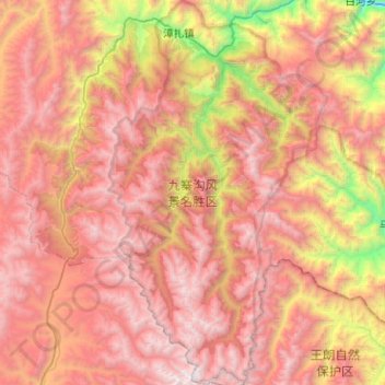
Nombre: Mapa topográfico Jiuzhai Valley National Park, altitud, relieve.
Altitud media: 3.424 m
Altitud mínima: 1.554 m
Altitud máxima: 4.859 m
The Jiuzhaigou valley is part of the Min Mountains on the edge of the Tibetan Plateau and stretches over 72,000 hectares (180,000 acres). It is known for its many multi-level waterfalls, colorful lakes, and snow-capped peaks. Its elevation ranges from 2,000 to 4,500 metres (6,600 to 14,800 ft).
Otros mapas topográficos
Haga clic en un mapa para ver su topografía, su altitud y su relieve.
Heye
China > Sichuan > Jiuzhaigou County
Heye, Jiuzhaigou County, Ngawa Tibetan and Qiang Autonomous Prefecture, Sichuan, 623400, China
Altitud media: 2.598 m
Jiuzhaigou
China > Sichuan > Jiuzhaigou County
Jiuzhaigou, Jiuzhaigou County, Ngawa Tibetan and Qiang Autonomous Prefecture, Sichuan, 623400, China
Altitud media: 2.520 m