Mapa topográfico Meizhou
Haga clic en el mapa para ver la altitud.
Meizhou
Meizhou has a humid subtropical climate (Köppen Cfa), with short, mild, overcast winters and long, very hot, humid summers. The monthly daily average temperature in January is 12.6 °C (54.7 °F), and in July is 28.9 °C (84.0 °F). From April to June, rainfall is the heaviest and most frequent. Though striking typhoons do not affect the area as much as the coast, the mountainous topography means that flooding is a serious concern. Record temperatures in the city have raged from −7.3 °C (18.9 °F) on January 12, 1955 (lowest reliably temperature ever recorded in Guangdong Province) to 39.5 °C (103.1 °F) in July 25, 1971.
Acerca de este mapa
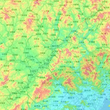
Nombre: Mapa topográfico Meizhou, altitud, relieve.
Lugar: Meizhou, Guangdong, China (23.37618 115.31160 24.94071 116.93493)
Altitud media: 297 m
Altitud mínima: -1 m
Altitud máxima: 1.479 m
Otros mapas topográficos
Haga clic en un mapa para ver su topografía, su altitud y su relieve.





Mount Yangtai
The Mount Yangtai (Chinese: 羊台山; pinyin: Yángtaíshān), also known as Mount Yangtai Forest Park, is a mountain at the junction of Bao'an District and Nanshan District in Shenzhen, Guangdong, China. The peak is 587.3 metres (1,927 ft) in elevation, which is the highest peak in western Shenzhen. In 2008…
Altitud media: 287 m