
Mapa topográfico Stade
Mapa interactivo
Haga clic en el mapa para ver la altitud.
Acerca de este mapa
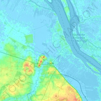
Nombre: Mapa topográfico Stade, altitud, relieve.
Lugar: Stade, Lower Saxony, Germany (53.53862 9.37406 53.70120 9.55063)
Altitud media: 4 m
Altitud mínima: -5 m
Altitud máxima: 35 m
Otros mapas topográficos
Haga clic en un mapa para ver su topografía, su altitud y su relieve.
Krummendeich
Germany > Lower Saxony > Stade
Krummendeich, Samtgemeinde Nordkehdingen, Stade, Lower Saxony, 21732, Germany
Altitud media: 0 m
Horneburg
Germany > Lower Saxony > Stade > Horneburg
Horneburg, Samtgemeinde Horneburg, Stade, Lower Saxony, Germany
Altitud media: 15 m