
Haz una donación
Equípate para tu próxima aventura:
Como asociado de Amazon, este sitio gana comisiones por las compras que califican, sin ningún costo adicional para usted.
Mapa topográfico Ellison Bay
Haga clic en el mapa para ver la altitud.
Haz una donación
Equípate para tu próxima aventura:
Como asociado de Amazon, este sitio gana comisiones por las compras que califican, sin ningún costo adicional para usted.
Acerca de este mapa
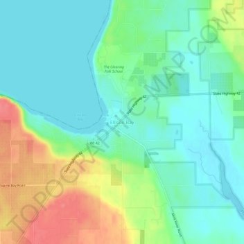
Nombre: Mapa topográfico Ellison Bay, altitud, relieve.
Altitud media: 194 m
Altitud mínima: 172 m
Altitud máxima: 238 m
Haz una donación
Equípate para tu próxima aventura:
Como asociado de Amazon, este sitio gana comisiones por las compras que califican, sin ningún costo adicional para usted.
Otros mapas topográficos
Haga clic en un mapa para ver su topografía, su altitud y su relieve.
Sturgeon Bay
United States > Wisconsin > Door County
Stevens Hill is a populated place within the city of Sturgeon Bay, just to the northeast of the downtown. The top of the hill has the highest elevation in the city. It is within Big Hill Park, which is 13.2 acres in area and is used for mountain biking, picnicking, and sledding.
Altitud media: 199 m
Haz una donación
Equípate para tu próxima aventura:
Como asociado de Amazon, este sitio gana comisiones por las compras que califican, sin ningún costo adicional para usted.