
Mapa topográfico Poole
Haga clic en el mapa para ver la altitud.
Acerca de este mapa
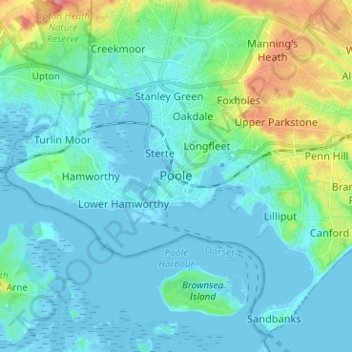
Nombre: Mapa topográfico Poole, altitud, relieve.
Altitud media: 16 m
Altitud mínima: -7 m
Altitud máxima: 87 m
Otros mapas topográficos
Haga clic en un mapa para ver su topografía, su altitud y su relieve.
Upton Heath Nature Reserve
United Kingdom > England > Bournemouth, Christchurch and Poole > Poole
Altitud media: 40 m
Christchurch
United Kingdom > England > Bournemouth, Christchurch and Poole > Hurn
Altitud media: 18 m
East Parley Common
United Kingdom > England > Bournemouth, Christchurch and Poole > Hurn
Altitud media: 13 m
Redhill Park
United Kingdom > England > Bournemouth, Christchurch and Poole > Bournemouth > Talbot Village
Altitud media: 33 m
Hamworthy Park
United Kingdom > England > Bournemouth, Christchurch and Poole > Poole
Altitud media: 2 m
Kings Park
United Kingdom > England > Bournemouth, Christchurch and Poole > Bournemouth
Altitud media: 31 m
Christchurch
United Kingdom > England > Bournemouth, Christchurch and Poole > Christchurch
Altitud media: 8 m
Christchurch
United Kingdom > England > Bournemouth, Christchurch and Poole > Christchurch
Altitud media: 18 m
Christchurch
United Kingdom > England > Bournemouth, Christchurch and Poole > Hurn
Altitud media: 18 m
Island in the Stour
United Kingdom > England > Bournemouth, Christchurch and Poole > Poole > Merley
Altitud media: 28 m
Christchurch
United Kingdom > England > Bournemouth, Christchurch and Poole > Hurn
Altitud media: 18 m