
Mapa topográfico Leeds and the Thousand Islands
Mapa interactivo
Haga clic en el mapa para ver la altitud.
Acerca de este mapa
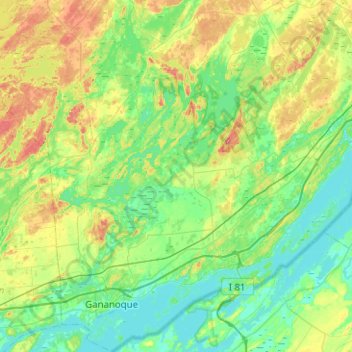
Nombre: Mapa topográfico Leeds and the Thousand Islands, altitud, relieve.
Altitud media: 102 m
Altitud mínima: 72 m
Altitud máxima: 185 m
Otros mapas topográficos
Haga clic en un mapa para ver su topografía, su altitud y su relieve.
Seeleys Bay
Canada > Ontario > Leeds and Grenville Counties > Leeds and the Thousand Islands > Seeley's Bay
Seeleys Bay, Seeley's Bay, Leeds and the Thousand Islands, Leeds and Grenville Counties, Eastern Ontario, Ontario, K0H 2N0, Canada
Altitud media: 105 m
Waterton
Canada > Ontario > Leeds and Grenville Counties > Leeds and the Thousand Islands > Waterton
Waterton, Leeds and the Thousand Islands, Leeds and Grenville Counties, Eastern Ontario, Ontario, Canada
Altitud media: 97 m