
Mapa topográfico Trnava
Mapa interactivo
Haga clic en el mapa para ver la altitud.
Acerca de este mapa
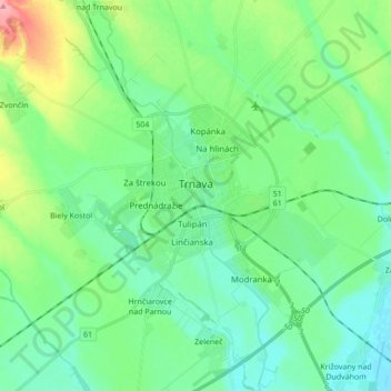
Nombre: Mapa topográfico Trnava, altitud, relieve.
Altitud media: 154 m
Altitud mínima: 129 m
Altitud máxima: 228 m
Trnava lies at an altitude of 146 metres (479 ft) above sea level and covers an area of 71.535 square kilometres (27.6 sq mi).[12] It is located in the Danubian Lowland on the Trnávka river, around 45 kilometres (28 mi) north-east of Bratislava, 50 kilometres (31 mi) west of Nitra and around 70 kilometres (43 mi) from the Czech border. The closest mountain ranges are the Little Carpathians to the west and the Považský Inovec to the north-east of the city.
Otros mapas topográficos
Haga clic en un mapa para ver su topografía, su altitud y su relieve.
Jaslovské Bohunice
Slovakia > Region of Trnava > District of Trnava > Jaslovské Bohunice > Jaslovské Bohunice
Jaslovské Bohunice, District of Trnava, Region of Trnava, Western Slovakia, 919 30, Slovakia
Altitud media: 169 m