Geolocalizar

Mapa topográfico Laleham

Haga clic en el mapa para ver la altitud.

Acerca de este mapa

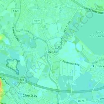
Nombre: Mapa topográfico Laleham, altitud, relieve.

Lugar: Laleham, Borough of Spelthorne, Surrey, England, TW18 1SD, United Kingdom (51.38890 -0.51027 51.42890 -0.47027)

Altitud media: 14 m

Altitud mínima: 7 m

Altitud máxima: 44 m

Otros mapas topográficos

Haga clic en un mapa para ver su topografía, su altitud y su relieve.

Shepperton

United Kingdom > England > Surrey > Borough of Spelthorne

Shepperton has a long boundary with the River Thames in its southernmost salient, which almost surrounds Spelthorne. Old Shepperton is almost surrounded by the extreme southern meander within this. Prehistoric glacial retreat north of this has made the north bank almost flat for a considerable distance and as…

Altitud media: 12 m

Equípate para tu próxima aventura:

🛏️Sacos de dormir - Sacos térmicos para montaña
🧴Impermeabilizante para Botas - Spray protector para mantener tus pies secos en cualquier mapa
🧢Gorras de senderismo - Protección solar para actividades al aire libre
🧢Gorras de Montaña - Protección contra los rayos UV en cumbres despejadas
🔌Paneles solares portátiles - Carga sostenible en ruta

Como asociado de Amazon, este sitio gana comisiones por las compras que califican, sin ningún costo adicional para usted.