
Haz una donación
Equípate para tu próxima aventura:
Como asociado de Amazon, este sitio gana comisiones por las compras que califican, sin ningún costo adicional para usted.
Mapa topográfico Hopkinton
Haga clic en el mapa para ver la altitud.
Haz una donación
Equípate para tu próxima aventura:
Como asociado de Amazon, este sitio gana comisiones por las compras que califican, sin ningún costo adicional para usted.
Hopkinton
According to the United States Census Bureau, the town has a total area of 45.1 square miles (116.8 km2), of which 43.3 square miles (112.1 km2) are land and 1.8 square miles (4.6 km2) are water, comprising 3.97% of the town. Hopkinton is drained by the Contoocook River and its tributary, the Warner River, except for the southeast part of town, which drains to the Turkey River. The highest point in town is Shaker Hill, on the border with Henniker, with an elevation of 923 feet (281 m) above sea level. Hopkinton lies fully within the Merrimack River watershed.
Haz una donación
Equípate para tu próxima aventura:
Como asociado de Amazon, este sitio gana comisiones por las compras que califican, sin ningún costo adicional para usted.
Acerca de este mapa
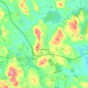
Nombre: Mapa topográfico Hopkinton, altitud, relieve.
Altitud media: 146 m
Altitud mínima: 89 m
Altitud máxima: 282 m
Haz una donación
Equípate para tu próxima aventura:
Como asociado de Amazon, este sitio gana comisiones por las compras que califican, sin ningún costo adicional para usted.
Otros mapas topográficos
Haga clic en un mapa para ver su topografía, su altitud y su relieve.
Haz una donación
Equípate para tu próxima aventura:
Como asociado de Amazon, este sitio gana comisiones por las compras que califican, sin ningún costo adicional para usted.
Haz una donación
Equípate para tu próxima aventura:
Como asociado de Amazon, este sitio gana comisiones por las compras que califican, sin ningún costo adicional para usted.
Haz una donación
Equípate para tu próxima aventura:
Como asociado de Amazon, este sitio gana comisiones por las compras que califican, sin ningún costo adicional para usted.
Haz una donación
Equípate para tu próxima aventura:
Como asociado de Amazon, este sitio gana comisiones por las compras que califican, sin ningún costo adicional para usted.
Rings Corner
United States > New Hampshire > Merrimack County > Pittsfield > Rings Corner
Altitud media: 190 m