
Haz una donación
Equípate para tu próxima aventura:
Como asociado de Amazon, este sitio gana comisiones por las compras que califican, sin ningún costo adicional para usted.
Mapa topográfico Olang - Valdaora
Haga clic en el mapa para ver la altitud.
Haz una donación
Equípate para tu próxima aventura:
Como asociado de Amazon, este sitio gana comisiones por las compras que califican, sin ningún costo adicional para usted.
Acerca de este mapa
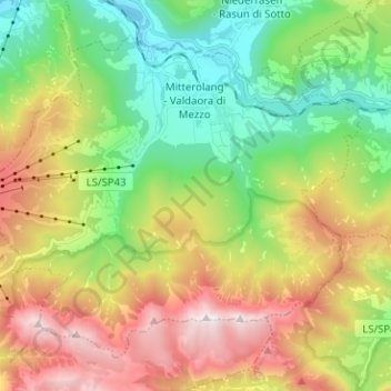
Nombre: Mapa topográfico Olang - Valdaora, altitud, relieve.
Altitud media: 1.585 m
Altitud mínima: 963 m
Altitud máxima: 2.541 m
Haz una donación
Equípate para tu próxima aventura:
Como asociado de Amazon, este sitio gana comisiones por las compras que califican, sin ningún costo adicional para usted.
Otros mapas topográficos
Haga clic en un mapa para ver su topografía, su altitud y su relieve.
Seiser Alm-Gruppe - Gruppo Mont de Sëuc - Gruppo dell'Alpe di Siusi
Italy > Trentino – Alto Adige/Südtirol > South Tyrol > Kastelruth - Castelrotto
Seiser Alm (Italian: Alpe di Siusi, Ladin: Mont Sëuc) is a Dolomite plateau and the largest high-elevation Alpine meadow (German: Alm) in Europe. Located in Italy's South Tyrol province in the Dolomites mountain range, it is a major tourist attraction, notably for skiing and hiking.
Altitud media: 1.466 m
Piz Boè
Italy > Trentino – Alto Adige/Südtirol > South Tyrol > Corvara in Badia - Corvara
Piz Boè is the highest mountain of the Sella group, a mountain range in the Dolomites, Italy. It has an elevation of 3,152 metres (10,341 ft).
Altitud media: 2.664 m
Gnates
Italy > Trentino – Alto Adige/Südtirol > South Tyrol > La Val - Wengen - La Valle
Altitud media: 1.504 m
Gisse
Italy > Trentino – Alto Adige/Südtirol > South Tyrol > Ahrntal - Valle Aurina
Altitud media: 1.368 m
Haz una donación
Equípate para tu próxima aventura:
Como asociado de Amazon, este sitio gana comisiones por las compras que califican, sin ningún costo adicional para usted.
Salotta
Italy > Trentino – Alto Adige/Südtirol > South Tyrol > San Ćiascian - St. Kassian - San Cassiano
Altitud media: 1.779 m
Meransen - Maranza
Italy > Trentino – Alto Adige/Südtirol > South Tyrol
Meransen (Italian: Maranza) is a village in South Tyrol, Italy, in the Mühlbach municipality between Pustertal and Eisacktal. It located on the slopes of the Gitschberg mountain at an altitude of 1,414 m (4,639 ft).
Altitud media: 1.279 m
Lengstein - Longostagno
Italy > Trentino – Alto Adige/Südtirol > South Tyrol > Ritten - Renon
Altitud media: 937 m
Wahlen - Valle San Silvestro
Italy > Trentino – Alto Adige/Südtirol > South Tyrol
Altitud media: 1.489 m
Haz una donación
Equípate para tu próxima aventura:
Como asociado de Amazon, este sitio gana comisiones por las compras que califican, sin ningún costo adicional para usted.
Klobenstein - Collalbo
Italy > Trentino – Alto Adige/Südtirol > South Tyrol > Ritten - Renon
Altitud media: 1.135 m
Raas - Rasa
Italy > Trentino – Alto Adige/Südtirol > South Tyrol > Natz-Schabs - Naz-Sciaves
Altitud media: 763 m
Haz una donación
Equípate para tu próxima aventura:
Como asociado de Amazon, este sitio gana comisiones por las compras que califican, sin ningún costo adicional para usted.
Milland - Millan
Italy > Trentino – Alto Adige/Südtirol > South Tyrol > Brixen - Bressanone
Altitud media: 769 m
St. Anton
Italy > Trentino – Alto Adige/Südtirol > South Tyrol > Völs am Schlern - Fiè allo Sciliar
Altitud media: 804 m
Prämajur
Italy > Trentino – Alto Adige/Südtirol > South Tyrol > Schleis - Clusio
Altitud media: 1.614 m
Armentarola
Italy > Trentino – Alto Adige/Südtirol > South Tyrol > Badia - Abtei
Altitud media: 1.886 m
Haz una donación
Equípate para tu próxima aventura:
Como asociado de Amazon, este sitio gana comisiones por las compras que califican, sin ningún costo adicional para usted.
Weitental - Vallarga
Italy > Trentino – Alto Adige/Südtirol > South Tyrol > Vintl - Vandoies
Altitud media: 1.306 m