
Mapa topográfico Village of Lattingtown
Mapa interactivo
Haga clic en el mapa para ver la altitud.
Acerca de este mapa
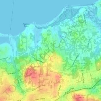
Nombre: Mapa topográfico Village of Lattingtown, altitud, relieve.
Altitud media: 20 m
Altitud mínima: -1 m
Altitud máxima: 62 m
Otros mapas topográficos
Haga clic en un mapa para ver su topografía, su altitud y su relieve.
Village of Kings Point
États-Unis d'Amérique > New York > Nassau County
Village of Kings Point, Town of North Hempstead, Nassau County, New York, 11024, États-Unis d'Amérique
Altitud media: 9 m
Village of Island Park
États-Unis d'Amérique > New York > Nassau County
Village of Island Park, Town of Hempstead, Nassau County, New York, 11558, États-Unis d'Amérique
Altitud media: 1 m
Village of Lynbrook
États-Unis d'Amérique > New York > Nassau County
Village of Lynbrook, Town of Hempstead, Nassau County, New York, 11563, États-Unis d'Amérique
Altitud media: 8 m
Village of Mineola
États-Unis d'Amérique > New York > Nassau County
Village of Mineola, Town of North Hempstead, Nassau County, New York, 11501, États-Unis d'Amérique
Altitud media: 35 m
Glen Head
États-Unis d'Amérique > New York > Nassau County
Glen Head, Town of Oyster Bay, Nassau County, New York, États-Unis d'Amérique
Altitud media: 40 m
Village of Westbury
États-Unis d'Amérique > New York > Nassau County
Village of Westbury, Town of North Hempstead, Nassau County, New York, États-Unis d'Amérique
Altitud media: 39 m
Village of Rockville Centre
États-Unis d'Amérique > New York > Nassau County
Village of Rockville Centre, Town of Hempstead, Nassau County, New York, 11570, États-Unis d'Amérique
Altitud media: 11 m