
Mapa topográfico Grand Canyon National Park
Mapa interactivo
Haga clic en el mapa para ver la altitud.
Acerca de este mapa
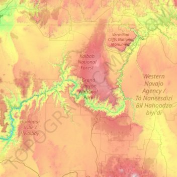
Nombre: Mapa topográfico Grand Canyon National Park, altitud, relieve.
Altitud media: 1.685 m
Altitud mínima: 513 m
Altitud máxima: 3.757 m
The North Rim area of the park is located on the Kaibab Plateau and Walhalla Plateau, directly across the Grand Canyon from the principal visitor areas on the South Rim. The North Rim's principal visitor areas are centered around Bright Angel Point. The North Rim is higher in elevation than the South Rim, at over 8,000 feet (2,400 m) of elevation. Because it is so much higher than the South Rim, it is closed from December 1 through May 15 each year, due to the enhanced snowfall at elevation. Visitor services are closed or limited in scope after October 15. Driving time from the South Rim to the North Rim is about 4.5 hours, over 220 miles (350 km).
Otros mapas topográficos
Haga clic en un mapa para ver su topografía, su altitud y su relieve.
Hoover Dam
United States > Arizona > Mohave County
Hoover Dam, Mohave County, Arizona, United States
Altitud media: 429 m
Pyramid Rock
United States > Arizona > Mohave County
Pyramid Rock, Mohave County, Arizona, United States
Altitud media: 1.419 m
Lake Havasu City
United States > Arizona > Mohave County > Lake Havasu City
Lake Havasu City, Mohave County, Arizona, 86403, United States
Altitud media: 411 m
Centennial Park
United States > Arizona > Mohave County
Centennial Park, Mohave County, Arizona, 86021, United States
Altitud media: 1.504 m