
Mapa topográfico Böhen
Mapa interactivo
Haga clic en el mapa para ver la altitud.
Acerca de este mapa
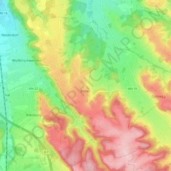
Nombre: Mapa topográfico Böhen, altitud, relieve.
Altitud media: 745 m
Altitud mínima: 649 m
Altitud máxima: 854 m
Otros mapas topográficos
Haga clic en un mapa para ver su topografía, su altitud y su relieve.
Legau
Deutschland > Bayern > Landkreis Unterallgäu
Legau, Illerwinkel, Landkreis Unterallgäu, Bayern, 87764, Deutschland
Altitud media: 675 m