
Haz una donación
Equípate para tu próxima aventura:
Como asociado de Amazon, este sitio gana comisiones por las compras que califican, sin ningún costo adicional para usted.
Mapa topográfico Balamban
Haga clic en el mapa para ver la altitud.
Haz una donación
Equípate para tu próxima aventura:
Como asociado de Amazon, este sitio gana comisiones por las compras que califican, sin ningún costo adicional para usted.
Balamban
Farming is another source of livelihood for residents with corn, crops and vegetables among the important crops. The municipality is also the only source of abaca fibers in Cebu produced in a 260-to-300-hectare (640-to-740-acre) plantation in Mount Manunggal in barangay Magsaysay. With the elevation of 500 metres (1,600 ft) above sea level, Magsaysay is ideal for abaca cultivation.
Haz una donación
Equípate para tu próxima aventura:
Como asociado de Amazon, este sitio gana comisiones por las compras que califican, sin ningún costo adicional para usted.
Acerca de este mapa
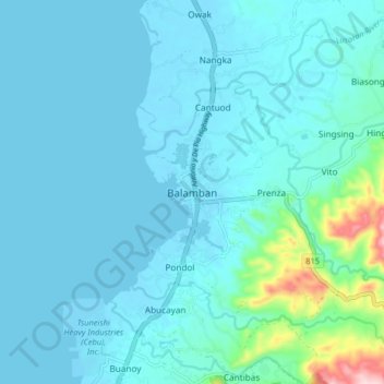
Nombre: Mapa topográfico Balamban, altitud, relieve.
Lugar: Balamban, Cebu, Central Visayas, 6041, Philippines (10.46489 123.67482 10.54489 123.75482)
Altitud media: 28 m
Altitud mínima: -2 m
Altitud máxima: 257 m
Haz una donación
Equípate para tu próxima aventura:
Como asociado de Amazon, este sitio gana comisiones por las compras que califican, sin ningún costo adicional para usted.
Otros mapas topográficos
Haga clic en un mapa para ver su topografía, su altitud y su relieve.
Oslob
Generally, the area's topography is hilly and rolling, dominated by open grasslands and second-growth forests. There are fairly level and rolling plateaus and valleys spread throughout the interior. These are some of the most suitable areas for upland agriculture. The highest mountain peak is 800 metres (2,600…
Altitud media: 99 m
Cordova
The surface of the town consists entirely of karstic limestone rock geologically associated with the Plio-Pleistocene Carcar Formation, dated to 2½–3 million years ago. The topography of Cordova is flat land, the highest point being only 10 metres (33 ft) above sea level.
Altitud media: 0 m
Haz una donación
Equípate para tu próxima aventura:
Como asociado de Amazon, este sitio gana comisiones por las compras que califican, sin ningún costo adicional para usted.
Haz una donación
Equípate para tu próxima aventura:
Como asociado de Amazon, este sitio gana comisiones por las compras que califican, sin ningún costo adicional para usted.
Carnaza
The island's topography includes coastal plains, mangrove swamps, lagoons and semi-rounded hills. Its coastal plain constitutes about 9.7% while semi-rounded hills constitute the biggest portion of the island covering about 14.4% of the total area. The mangrove forest has an area of about 10.1 hectares or 5.8%…
Altitud media: 0 m
Haz una donación
Equípate para tu próxima aventura:
Como asociado de Amazon, este sitio gana comisiones por las compras que califican, sin ningún costo adicional para usted.
Haz una donación
Equípate para tu próxima aventura:
Como asociado de Amazon, este sitio gana comisiones por las compras que califican, sin ningún costo adicional para usted.
Haz una donación
Equípate para tu próxima aventura:
Como asociado de Amazon, este sitio gana comisiones por las compras que califican, sin ningún costo adicional para usted.
Haz una donación
Equípate para tu próxima aventura:
Como asociado de Amazon, este sitio gana comisiones por las compras que califican, sin ningún costo adicional para usted.
Haz una donación
Equípate para tu próxima aventura:
Como asociado de Amazon, este sitio gana comisiones por las compras que califican, sin ningún costo adicional para usted.
Oslob
Generally, the area's topography is hilly and rolling, dominated by open grasslands and second-growth forests. There are fairly level and rolling plateaus and valleys spread throughout the interior. These are some of the most suitable areas for upland agriculture. The highest mountain peak is 800 metres (2,600…
Altitud media: 99 m
Haz una donación
Equípate para tu próxima aventura:
Como asociado de Amazon, este sitio gana comisiones por las compras que califican, sin ningún costo adicional para usted.
Haz una donación
Equípate para tu próxima aventura:
Como asociado de Amazon, este sitio gana comisiones por las compras que califican, sin ningún costo adicional para usted.
Haz una donación
Equípate para tu próxima aventura:
Como asociado de Amazon, este sitio gana comisiones por las compras que califican, sin ningún costo adicional para usted.
Haz una donación
Equípate para tu próxima aventura:
Como asociado de Amazon, este sitio gana comisiones por las compras que califican, sin ningún costo adicional para usted.