
Mapa topográfico Larzey
Mapa interactivo
Haga clic en el mapa para ver la altitud.
Acerca de este mapa
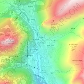
Nombre: Mapa topográfico Larzey, altitud, relieve.
Lugar: Larzey, Courmayeur, Aosta Valley, 11013, Italy (45.77887 6.95038 45.81887 6.99038)
Altitud media: 1.596 m
Altitud mínima: 1.095 m
Altitud máxima: 2.320 m
Otros mapas topográficos
Haga clic en un mapa para ver su topografía, su altitud y su relieve.
Mont Blanc - Monte Bianco
Italy > Aosta Valley > Courmayeur
Mont Blanc - Monte Bianco, Sentiero per Rifugio Monzino, Courmayeur, Aosta Valley, Italy
Altitud media: 4.092 m
Val Veny
Italy > Aosta Valley > Courmayeur
Val Veny, Courmayeur, Aosta Valley, Italy
Altitud media: 2.151 m
Ghiacciaio del Miage
Italy > Aosta Valley > Courmayeur
Ghiacciaio del Miage, Sentiero 15 Rifugio Gonella, Courmayeur, Aosta Valley, Italy
Altitud media: 2.911 m