
Mapa topográfico Clayton
Mapa interactivo
Haga clic en el mapa para ver la altitud.
Acerca de este mapa
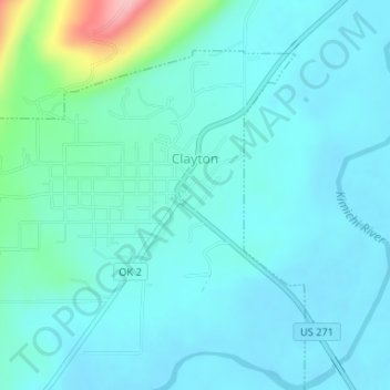
Nombre: Mapa topográfico Clayton, altitud, relieve.
Lugar: Clayton, Pushmataha County, Oklahoma, 74536, United States (34.57541 -95.37129 34.59851 -95.34265)
Altitud media: 188 m
Altitud mínima: 162 m
Altitud máxima: 330 m
Clayton, located in the Kiamichi River valley, is framed on its west by Flagpole Mountain (1,562 ft.) and to its east by unnamed mountains topping 1,600 feet in elevation. Within a few miles of Clayton is scenic McKinley Rocks, a collection of massive boulders strewn across a mountain top. South of Clayton is Clayton Lake State Park—which is surrounded by a pine tree forest—and northwest of town is Sardis Lake, a U.S. Army Corps of Engineers dam which impounds the water of Jack's Fork Creek. The Pushmataha Wildlife Refuge is also nearby, featuring scenic views from its mountain summit.
Otros mapas topográficos
Haga clic en un mapa para ver su topografía, su altitud y su relieve.
Finley
United States > Oklahoma > Pushmataha County
Finley, Pushmataha County, Oklahoma, 74543, United States
Altitud media: 155 m
Nashoba
United States > Oklahoma > Pushmataha County
Nashoba, Pushmataha County, Oklahoma, 74558, United States
Altitud media: 233 m
Albion
United States > Oklahoma > Pushmataha County > Albion
Albion, Pushmataha County, Oklahoma, 74524, United States
Altitud media: 207 m
Antlers
United States > Oklahoma > Pushmataha County
Antlers, Pushmataha County, Oklahoma, United States
Altitud media: 154 m