
Haz una donación
Equípate para tu próxima aventura:
Como asociado de Amazon, este sitio gana comisiones por las compras que califican, sin ningún costo adicional para usted.
Mapa topográfico Donges Bay
Haga clic en el mapa para ver la altitud.
Haz una donación
Equípate para tu próxima aventura:
Como asociado de Amazon, este sitio gana comisiones por las compras que califican, sin ningún costo adicional para usted.
Acerca de este mapa
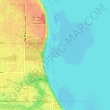
Nombre: Mapa topográfico Donges Bay, altitud, relieve.
Lugar: Donges Bay, Ozaukee County, Wisconsin, 53092, United States (43.20357 -87.89430 43.20367 -87.89420)
Altitud media: 190 m
Altitud mínima: 171 m
Altitud máxima: 225 m
Haz una donación
Equípate para tu próxima aventura:
Como asociado de Amazon, este sitio gana comisiones por las compras que califican, sin ningún costo adicional para usted.
Otros mapas topográficos
Haga clic en un mapa para ver su topografía, su altitud y su relieve.
Port Washington
United States > Wisconsin > Ozaukee County
The city is located on the western shore of Lake Michigan. In northern and southern parts of the city, the coastline is characterized by clay bluffs ranging from 80 feet (24 meters) to 130 feet (40 meters) in height with deep ravines where streams flow into the lake. Clay bluffs are a geological formation…
Altitud media: 205 m
Haz una donación
Equípate para tu próxima aventura:
Como asociado de Amazon, este sitio gana comisiones por las compras que califican, sin ningún costo adicional para usted.
Port Washington
United States > Wisconsin > Ozaukee County
The city is located on the western shore of Lake Michigan. In northern and southern parts of the city, the coastline is characterized by clay bluffs ranging from 80 feet (24 meters) to 130 feet (40 meters) in height with deep ravines where streams flow into the lake. Clay bluffs are a geological formation…
Altitud media: 201 m
Haz una donación
Equípate para tu próxima aventura:
Como asociado de Amazon, este sitio gana comisiones por las compras que califican, sin ningún costo adicional para usted.
Haz una donación
Equípate para tu próxima aventura:
Como asociado de Amazon, este sitio gana comisiones por las compras que califican, sin ningún costo adicional para usted.