Geolocalizar

Mapa topográfico Cavinti

Haga clic en el mapa para ver la altitud.

Acerca de este mapa

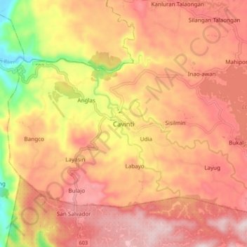
Nombre: Mapa topográfico Cavinti, altitud, relieve.

Lugar: Cavinti, Laguna, Calabarzon, 4013, Philippines (14.20538 121.46700 14.28538 121.54700)

Altitud media: 250 m

Altitud mínima: 5 m

Altitud máxima: 391 m

Otros mapas topográficos

Haga clic en un mapa para ver su topografía, su altitud y su relieve.

Anglas

Philippines > Laguna > Cavinti

Altitud media: 204 m

Bumbungan River

Philippines > Laguna > Cavinti

The waterfalls for which the Bumbungan river is famous is the Magdapio Falls, a section of the river in the town of Cavinti where the river drops about 300 feet (91 m). Because the original boat ride to reach the falls starts in Pagsanjan, it became known as the Pagsanjan Falls. This round trip boat ride…

Altitud media: 260 m

Sumucab

Philippines > Laguna > Cavinti

Altitud media: 373 m

Duhat

Philippines > Laguna > Cavinti

Altitud media: 221 m

Silangan Talaongan

Philippines > Laguna > Cavinti

Altitud media: 288 m

Equípate para tu próxima aventura:

🛡️Fundas Impermeables para Mochila - Mantén tu equipo y mapas secos bajo cualquier tormenta
🔦Linternas frontales - Iluminación frontal para rutas nocturnas
🧭Brújulas de Orientación - Herramienta clásica esencial para lectura de mapas topográficos
🦯Bastones de senderismo - Bastones ajustables para estabilidad en ruta
🧴Protector solar montaña - Protección UV en altitud

Como asociado de Amazon, este sitio gana comisiones por las compras que califican, sin ningún costo adicional para usted.