
Haz una donación
Equípate para tu próxima aventura:
Como asociado de Amazon, este sitio gana comisiones por las compras que califican, sin ningún costo adicional para usted.
Mapa topográfico Maitland
Haga clic en el mapa para ver la altitud.
Haz una donación
Equípate para tu próxima aventura:
Como asociado de Amazon, este sitio gana comisiones por las compras que califican, sin ningún costo adicional para usted.
Acerca de este mapa
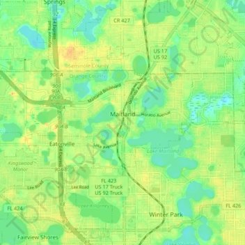
Nombre: Mapa topográfico Maitland, altitud, relieve.
Lugar: Maitland, Orange County, Florida, 32751, United States (28.60952 -81.41082 28.64041 -81.32834)
Altitud media: 30 m
Altitud mínima: 14 m
Altitud máxima: 46 m
Haz una donación
Equípate para tu próxima aventura:
Como asociado de Amazon, este sitio gana comisiones por las compras que califican, sin ningún costo adicional para usted.
Otros mapas topográficos
Haga clic en un mapa para ver su topografía, su altitud y su relieve.
Orlando
United States > Florida > Orange County
According to the Köppen climate classification, Orlando has a humid subtropical climate (Cfa) like much of the deep Southern United States. The two basic seasons in Orlando are a hot and rainy season, lasting from May until late October (roughly coinciding with the Atlantic hurricane season), and a warm and…
Altitud media: 29 m
Haz una donación
Equípate para tu próxima aventura:
Como asociado de Amazon, este sitio gana comisiones por las compras que califican, sin ningún costo adicional para usted.
Union Park
United States > Florida > Orange County
According to the United States Census Bureau, the CDP has a total area of 7.8 km2 (3.0 mi2), of which 7.7 km2 (3.0 mi2) is land and 0.1 km2 (0.04 mi2) (0.99%) is water. The elevation is 82 feet (25 m) above sea level.
Altitud media: 16 m
Haz una donación
Equípate para tu próxima aventura:
Como asociado de Amazon, este sitio gana comisiones por las compras que califican, sin ningún costo adicional para usted.
Haz una donación
Equípate para tu próxima aventura:
Como asociado de Amazon, este sitio gana comisiones por las compras que califican, sin ningún costo adicional para usted.
Haz una donación
Equípate para tu próxima aventura:
Como asociado de Amazon, este sitio gana comisiones por las compras que califican, sin ningún costo adicional para usted.
Haz una donación
Equípate para tu próxima aventura:
Como asociado de Amazon, este sitio gana comisiones por las compras que califican, sin ningún costo adicional para usted.
Haz una donación
Equípate para tu próxima aventura:
Como asociado de Amazon, este sitio gana comisiones por las compras que califican, sin ningún costo adicional para usted.
Union Park
United States > Florida > Orange County
According to the United States Census Bureau, the CDP has a total area of 7.8 km2 (3.0 mi2), of which 7.7 km2 (3.0 mi2) is land and 0.1 km2 (0.04 mi2) (0.99%) is water. The elevation is 82 feet (25 m) above sea level.
Altitud media: 16 m