
Haz una donación
Equípate para tu próxima aventura:
Como asociado de Amazon, este sitio gana comisiones por las compras que califican, sin ningún costo adicional para usted.
Mapa topográfico Anna
Haga clic en el mapa para ver la altitud.
Haz una donación
Equípate para tu próxima aventura:
Como asociado de Amazon, este sitio gana comisiones por las compras que califican, sin ningún costo adicional para usted.
Anna
The coming of the railroad can be credited for prompting the founding of the City of Anna, although, from the time of the George Rogers Clark expedition into Southern Illinois country, emigrants recognized its agricultural possibilities. Centrally located in Anna Precinct of Union County, Anna was established by ordinance following the election of Trustees in 1855, although the plot was recorded in the county records on March 3, 1854. The area's elevation and fertile soil have made fruit farming—particularly the growth of grapes for winemaking—one of the area's principal businesses. For the purpose of farming, fruit growing, gardening, and dairying, the lands in and around Anna are not surpassed in Southern Illinois. The precinct in which Anna lies is situated on the divide between the waters of the Ohio and Mississippi Rivers and is well drained by the Cache, Cypress, and Big Creeks. Many cool springs of water aid materially in cattle farming in this area.
Haz una donación
Equípate para tu próxima aventura:
Como asociado de Amazon, este sitio gana comisiones por las compras que califican, sin ningún costo adicional para usted.
Acerca de este mapa
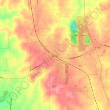
Nombre: Mapa topográfico Anna, altitud, relieve.
Lugar: Anna, Union County, Illinois, 62906, United States (37.44547 -89.26132 37.47584 -89.20744)
Altitud media: 183 m
Altitud mínima: 108 m
Altitud máxima: 218 m
Haz una donación
Equípate para tu próxima aventura:
Como asociado de Amazon, este sitio gana comisiones por las compras que califican, sin ningún costo adicional para usted.
Otros mapas topográficos
Haga clic en un mapa para ver su topografía, su altitud y su relieve.