
Mapa topográfico West Byfleet
Haga clic en el mapa para ver la altitud.
West Byfleet
The surface undulates gently from the west to the east, where West Byfleet's land is drained in the parish of Byfleet itself by the River Wey. Soil ranges from sandy acidic soil in the west to more alluvial soil in the east, underlain by a mixture of gravel and clay. Elevations range from 18m Above Ordnance Datum to 33m.
Acerca de este mapa
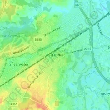
Nombre: Mapa topográfico West Byfleet, altitud, relieve.
Altitud media: 26 m
Altitud mínima: 13 m
Altitud máxima: 52 m
Otros mapas topográficos
Haga clic en un mapa para ver su topografía, su altitud y su relieve.
Horsell Common
United Kingdom > England > Surrey > Woking > Horsell > Durnford Farm
Altitud media: 29 m