
Mapa topográfico Lake of the Woods County
Mapa interactivo
Haga clic en el mapa para ver la altitud.
Acerca de este mapa
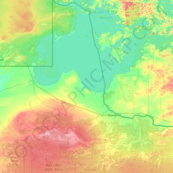
Nombre: Mapa topográfico Lake of the Woods County, altitud, relieve.
Lugar: Lake of the Woods County, Minnesota, USA (48.36906 -95.34261 49.38449 -94.43111)
Altitud media: 343 m
Altitud mínima: 317 m
Altitud máxima: 405 m
Otros mapas topográficos
Haga clic en un mapa para ver su topografía, su altitud y su relieve.
St. Michael
USA > Minnesota > St. Michael
St. Michael, Wright County, Minnesota, 55376, USA
Altitud media: 290 m
Alexandria
USA > Minnesota > Alexandria
Alexandria, Douglas County, Minnesota, 56308, USA
Altitud media: 426 m
Hula Lake
USA > Minnesota > Silver Rapids
Hula Lake, Fernberg Trl; Fernberg Rd, Silver Rapids, Lake County, Minnesota, USA
Altitud media: 411 m