
Haz una donación
Equípate para tu próxima aventura:
Como asociado de Amazon, este sitio gana comisiones por las compras que califican, sin ningún costo adicional para usted.
Mapa topográfico Tiger Valley
Haga clic en el mapa para ver la altitud.
Haz una donación
Equípate para tu próxima aventura:
Como asociado de Amazon, este sitio gana comisiones por las compras que califican, sin ningún costo adicional para usted.
Acerca de este mapa
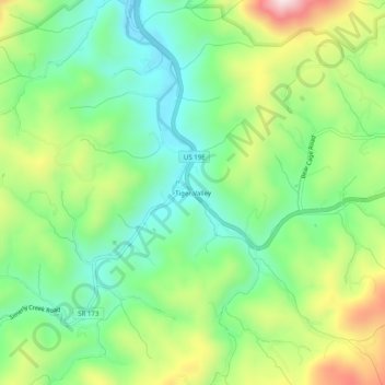
Nombre: Mapa topográfico Tiger Valley, altitud, relieve.
Altitud media: 747 m
Altitud mínima: 583 m
Altitud máxima: 1.040 m
Haz una donación
Equípate para tu próxima aventura:
Como asociado de Amazon, este sitio gana comisiones por las compras que califican, sin ningún costo adicional para usted.
Otros mapas topográficos
Haga clic en un mapa para ver su topografía, su altitud y su relieve.
Watauga Lake
United States > Tennessee > Carter County
According to the 2004 TVA River and Reservoir Operations Study, Watauga Lake is approximately 16.3 mi (26.2 km) long, with 104.9 mi (168.8 km) of shoreline. At the TVA summertime water level target "full pool", the lake surface covers 6,430 acres (26 km²) and the estimated depth of Watauga Lake is 265 feet…
Altitud media: 755 m
Roan Mountain
United States > Tennessee > Carter County
Roan Mountain is located in northeast Tennessee at 36°11′39″N 82°4′6″W / 36.19417°N 82.06833°W / 36.19417; -82.06833 (36.194219, -82.068417). According to the United States Census Bureau, the CDP has a total area of 6.6 square miles (17.2 km2), all land. The elevation of Roan Mountain near…
Altitud media: 926 m
Elizabethton
United States > Tennessee > Carter County
The elevation at Elizabethton Municipal Airport is 1,593 feet (486 m) ASL (the highest point of elevation in Carter County is at Roan Mountain with an elevation of 6,285 feet (1,916 m) ASL), and the airport is located on the eastern side of the city along State Highway 91 Stoney Creek Exit. Elizabethton is…
Altitud media: 567 m
Haz una donación
Equípate para tu próxima aventura:
Como asociado de Amazon, este sitio gana comisiones por las compras que califican, sin ningún costo adicional para usted.