
Mapa topográfico Žilina
Mapa interactivo
Haga clic en el mapa para ver la altitud.
Acerca de este mapa
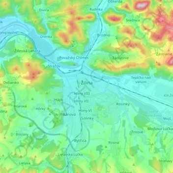
Nombre: Mapa topográfico Žilina, altitud, relieve.
Altitud media: 424 m
Altitud mínima: 314 m
Altitud máxima: 792 m
Žilina lies at an altitude of 342 metres (1,122 ft) above sea level and covers an area of 80.03 square kilometres (30.9 sq mi). It is located in the Upper Váh region (Slovak: Horné Považie) at the confluence of three rivers: Váh, flowing from the east into the south-west, Kysuca, flowing from the north and Rajčanka rivers from the south, in the Žilina Basin. The city is surrounded by these mountain ranges: Malá Fatra, Súľovské vrchy, Javorníky and Kysucká vrchovina. Protected areas nearby include the Strážov Mountains Protected Landscape Area, the Kysuce Protected Landscape Area, and the Malá Fatra National Park. There are two hydroelectric dams on the Váh river around Žilina: the Žilina dam in the east and the Hričov dam in the west.
Otros mapas topográficos
Haga clic en un mapa para ver su topografía, su altitud y su relieve.
Turky
Slovakia > Region of Žilina > District of Žilina > Rosina
Turky, Rosina, District of Žilina, Region of Žilina, Central Slovakia, 013 12, Slovakia
Altitud media: 451 m
Žilina
Slovakia > Region of Žilina > District of Žilina > Žilina
Žilina, District of Žilina, Region of Žilina, Central Slovakia, 01242, Slovakia
Altitud media: 569 m
Dolný Hričov
Slovakia > Region of Žilina > District of Žilina
Dolný Hričov, District of Žilina, Region of Žilina, Central Slovakia, 013 41, Slovakia
Altitud media: 435 m
Terchová
Slovakia > Region of Žilina > District of Žilina
Terchová, District of Žilina, Region of Žilina, Central Slovakia, 013 06, Slovakia
Altitud media: 819 m