
Haz una donación
Equípate para tu próxima aventura:
Como asociado de Amazon, este sitio gana comisiones por las compras que califican, sin ningún costo adicional para usted.
Mapa topográfico Midvaal Local Municipality
Haga clic en el mapa para ver la altitud.
Haz una donación
Equípate para tu próxima aventura:
Como asociado de Amazon, este sitio gana comisiones por las compras que califican, sin ningún costo adicional para usted.
Acerca de este mapa
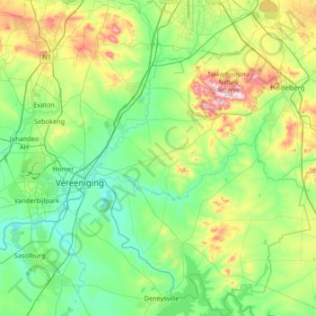
Nombre: Mapa topográfico Midvaal Local Municipality, altitud, relieve.
Altitud media: 1.531 m
Altitud mínima: 1.412 m
Altitud máxima: 1.909 m
Haz una donación
Equípate para tu próxima aventura:
Como asociado de Amazon, este sitio gana comisiones por las compras que califican, sin ningún costo adicional para usted.
Otros mapas topográficos
Haga clic en un mapa para ver su topografía, su altitud y su relieve.
Sebokeng
South Africa > Gauteng > Sedibeng District Municipality > Emfuleni Local Municipality
Altitud media: 1.523 m
Evaton
South Africa > Gauteng > Sedibeng District Municipality > Emfuleni Local Municipality
Altitud media: 1.522 m
Vanderbijlpark
South Africa > Gauteng > Sedibeng District Municipality > Emfuleni Local Municipality
Vanderbijlpark is situated on the highveld of South Africa, at an altitude of 1,500 meters on the banks of the Vaal River. Summers in the city are warm to hot with an average high between 31 and 35°C, and an average low between 15 and 22°C. Winters in the city are cool to warm with an average high of between…
Altitud media: 1.474 m
Haz una donación
Equípate para tu próxima aventura:
Como asociado de Amazon, este sitio gana comisiones por las compras que califican, sin ningún costo adicional para usted.
Meyerton
South Africa > Gauteng > Sedibeng District Municipality > Midvaal Local Municipality
Altitud media: 1.479 m
Suikerbosrand Nature Reserve
South Africa > Gauteng > Sedibeng District Municipality > Lesedi Local Municipality
Suikerbosrand Nature Reserve is a protected area which encompasses most of the Suikerbosrand Range, South Africa. It is one of Gauteng's most frequented ecotourism locations, located approximately 50 kilometres south-east of Johannesburg, just west of the town of Heidelberg in the upper catchment of the Klip…
Altitud media: 1.617 m
De Deur
South Africa > Gauteng > Sedibeng District Municipality > Midvaal Local Municipality
Altitud media: 1.547 m
Boipatong
South Africa > Gauteng > Sedibeng District Municipality > Emfuleni Local Municipality
Altitud media: 1.478 m
Haz una donación
Equípate para tu próxima aventura:
Como asociado de Amazon, este sitio gana comisiones por las compras que califican, sin ningún costo adicional para usted.
Modderfontein
South Africa > Gauteng > Sedibeng District Municipality > Midvaal Local Municipality
Altitud media: 1.534 m
Sharpeville
South Africa > Gauteng > Sedibeng District Municipality > Emfuleni Local Municipality
Altitud media: 1.459 m
Bass Lake
South Africa > Gauteng > Sedibeng District Municipality > Midvaal Local Municipality
Altitud media: 1.473 m
Sebokeng
South Africa > Gauteng > Sedibeng District Municipality > Emfuleni Local Municipality
Altitud media: 1.523 m
Haz una donación
Equípate para tu próxima aventura:
Como asociado de Amazon, este sitio gana comisiones por las compras que califican, sin ningún costo adicional para usted.
Sharpeville
South Africa > Gauteng > Sedibeng District Municipality > Emfuleni Local Municipality
Altitud media: 1.459 m
Heidelberg
South Africa > Gauteng > Sedibeng District Municipality > Lesedi Local Municipality
Altitud media: 1.581 m
Meyerton
South Africa > Gauteng > Sedibeng District Municipality > Midvaal Local Municipality
Altitud media: 1.479 m
Sebokeng
South Africa > Gauteng > Sedibeng District Municipality > Emfuleni Local Municipality
Altitud media: 1.523 m
Haz una donación
Equípate para tu próxima aventura:
Como asociado de Amazon, este sitio gana comisiones por las compras que califican, sin ningún costo adicional para usted.
Walkerville
South Africa > Gauteng > Sedibeng District Municipality > Midvaal Local Municipality
Altitud media: 1.632 m
Sharpeville
South Africa > Gauteng > Sedibeng District Municipality > Emfuleni Local Municipality
Altitud media: 1.459 m
Boipatong
South Africa > Gauteng > Sedibeng District Municipality > Emfuleni Local Municipality
Altitud media: 1.478 m
Haz una donación
Equípate para tu próxima aventura:
Como asociado de Amazon, este sitio gana comisiones por las compras que califican, sin ningún costo adicional para usted.
CW2
South Africa > Gauteng > Sedibeng District Municipality > Emfuleni Local Municipality
Altitud media: 1.501 m
SE10
South Africa > Gauteng > Sedibeng District Municipality > Emfuleni Local Municipality
Altitud media: 1.462 m
Evaton
South Africa > Gauteng > Sedibeng District Municipality > Emfuleni Local Municipality
Altitud media: 1.522 m
Haz una donación
Equípate para tu próxima aventura:
Como asociado de Amazon, este sitio gana comisiones por las compras que califican, sin ningún costo adicional para usted.
SE8
South Africa > Gauteng > Sedibeng District Municipality > Emfuleni Local Municipality
Altitud media: 1.456 m
Modderfontein
South Africa > Gauteng > Sedibeng District Municipality > Midvaal Local Municipality
Altitud media: 1.534 m
NW7
South Africa > Gauteng > Sedibeng District Municipality > Emfuleni Local Municipality
Altitud media: 1.497 m
Haz una donación
Equípate para tu próxima aventura:
Como asociado de Amazon, este sitio gana comisiones por las compras que califican, sin ningún costo adicional para usted.
Vaal Marina Community Center
South Africa > Gauteng > Sedibeng District Municipality > Midvaal Local Municipality
Altitud media: 1.526 m
SE1
South Africa > Gauteng > Sedibeng District Municipality > Emfuleni Local Municipality
Altitud media: 1.480 m