
Mapa topográfico Ranger
Mapa interactivo
Haga clic en el mapa para ver la altitud.
Acerca de este mapa
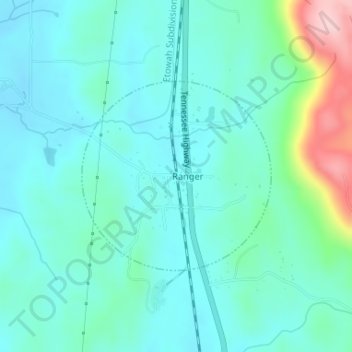
Nombre: Mapa topográfico Ranger, altitud, relieve.
Lugar: Ranger, Gordon County, Georgia, United States (34.49385 -84.71972 34.50839 -84.70208)
Altitud media: 252 m
Altitud mínima: 212 m
Altitud máxima: 416 m
Otros mapas topográficos
Haga clic en un mapa para ver su topografía, su altitud y su relieve.
Sugar Valley
United States > Georgia > Gordon County
Sugar Valley, Gordon County, Georgia, 30746, United States
Altitud media: 208 m
Plainville
United States > Georgia > Gordon County
Plainville, Gordon County, Georgia, United States
Altitud media: 213 m
Calhoun
United States > Georgia > Gordon County
Calhoun, Gordon County, Georgia, 30701, United States
Altitud media: 210 m
City of Plainville
United States > Georgia > Gordon County
City of Plainville, Gordon County, Georgia, United States
Altitud media: 213 m
Fairmount
United States > Georgia > Gordon County
Fairmount, Gordon County, Georgia, United States
Altitud media: 249 m
Calhoun
United States > Georgia > Gordon County > Calhoun > Calhoun
Calhoun, Gordon County, Georgia, 30701, United States
Altitud media: 206 m