
Mapa topográfico Winsick
Haga clic en el mapa para ver la altitud.
Acerca de este mapa
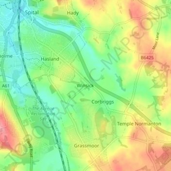
Nombre: Mapa topográfico Winsick, altitud, relieve.
Altitud media: 110 m
Altitud mínima: 72 m
Altitud máxima: 164 m
Otros mapas topográficos
Haga clic en un mapa para ver su topografía, su altitud y su relieve.
Doghole Wood
United Kingdom > England > Derbyshire > North East Derbyshire > Holymoorside
Altitud media: 142 m
Ogston Reservoir
United Kingdom > England > Derbyshire > North East Derbyshire > Woolley Moor
Altitud media: 137 m
Dronfield Nature Park
United Kingdom > England > Derbyshire > North East Derbyshire > Dronfield > Unstone Green
Altitud media: 156 m
Ashover CP
United Kingdom > England > Derbyshire > North East Derbyshire
By the 18th century, there were several thousand acres of unenclosed moorland in the parish of Ashover, principally covered with heath. The only paths across this wilderness for roads were tracks in the sand or heath with here and there a stone post on the hills or elevations to serve as guides to the…
Altitud media: 210 m
Norwood Cottage Lakes
United Kingdom > England > Derbyshire > North East Derbyshire > Killamarsh
Altitud media: 93 m
Grassmoor Country Park
United Kingdom > England > Derbyshire > North East Derbyshire > Corbriggs
Altitud media: 116 m
Holmesfield
United Kingdom > England > Derbyshire > North East Derbyshire > Holmesfield
Altitud media: 233 m