
Mapa topográfico Worstead
Haga clic en el mapa para ver la altitud.
Acerca de este mapa
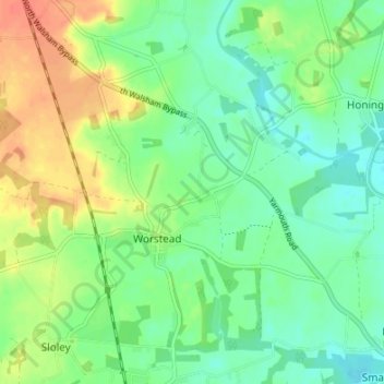
Nombre: Mapa topográfico Worstead, altitud, relieve.
Lugar: Worstead, North Norfolk, Norfolk, England, United Kingdom (52.77038 1.37669 52.80502 1.44407)
Altitud media: 17 m
Altitud mínima: 0 m
Altitud máxima: 43 m
Otros mapas topográficos
Haga clic en un mapa para ver su topografía, su altitud y su relieve.
Beacon Hill
United Kingdom > England > Norfolk > North Norfolk
Beacon Hill is a part of the Cromer Ridge which is a ridge of old glacial moraines (terminal moraine) that stands next to the coast above Cromer. The Cromer Ridge seems to have been the front line of the ice sheet for some time at the last glaciations, which is shown by the large size of the feature. All the…
Altitud media: 65 m
Sheringham Park
United Kingdom > England > Norfolk > North Norfolk > Upper Sheringham
Altitud media: 61 m
Johnson Street
United Kingdom > England > Norfolk > North Norfolk > Ludham > Johnson Street
Altitud media: 3 m
North Walsham and Dilham Canal
United Kingdom > England > Norfolk > North Norfolk > Honing
Altitud media: 21 m
Ridlington
United Kingdom > England > Norfolk > North Norfolk > Witton and Ridlington
Altitud media: 9 m
Beeston Bump
United Kingdom > England > Norfolk > North Norfolk > Sheringham > Beeston Regis
Altitud media: 20 m
Newgate
United Kingdom > England > Norfolk > North Norfolk > Cley next the Sea > Newgate
Altitud media: 22 m
Bacton Green
United Kingdom > England > Norfolk > North Norfolk > Bacton > Bacton Green
Altitud media: 9 m