
Mapa topográfico Zlatibor
Mapa interactivo
Haga clic en el mapa para ver la altitud.
Acerca de este mapa
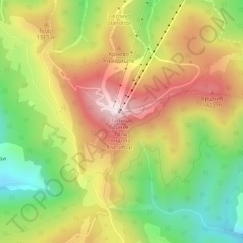
Nombre: Mapa topográfico Zlatibor, altitud, relieve.
Altitud media: 1.218 m
Altitud mínima: 956 m
Altitud máxima: 1.487 m
Zlatibor itself is located in the northern part of the Stari Vlah region, a historical border region between Raška, Herzegovina and Bosnia. It spreads over an area of 300 square kilometres (120 square miles), 43 km (27 mi) in length, southeast to northwest, and up to 37 km (23 mi) in width. Its highest peak, Tornik, has an elevation of 1,496 m. Zlatibor is situated between 43° 31' N, and 43° 51' N, and between 19° 28' E and 19° 56' E.
Otros mapas topográficos
Haga clic en un mapa para ver su topografía, su altitud y su relieve.
Dobroselica
Serbia > Central Serbia > Zlatibor Administrative District > Cajetina Municipality
Dobroselica, Cajetina Municipality, Zlatibor Administrative District, Central Serbia, Serbia
Altitud media: 971 m