
Haz una donación
Equípate para tu próxima aventura:
Como asociado de Amazon, este sitio gana comisiones por las compras que califican, sin ningún costo adicional para usted.
Mapa topográfico Blairsville
Haga clic en el mapa para ver la altitud.
Haz una donación
Equípate para tu próxima aventura:
Como asociado de Amazon, este sitio gana comisiones por las compras que califican, sin ningún costo adicional para usted.
Acerca de este mapa
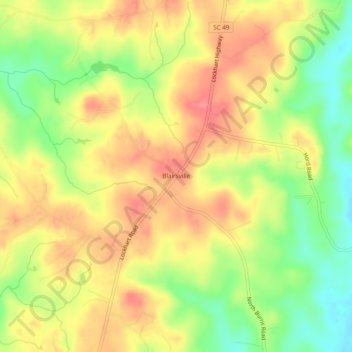
Nombre: Mapa topográfico Blairsville, altitud, relieve.
Altitud media: 176 m
Altitud mínima: 133 m
Altitud máxima: 209 m
Haz una donación
Equípate para tu próxima aventura:
Como asociado de Amazon, este sitio gana comisiones por las compras que califican, sin ningún costo adicional para usted.
Otros mapas topográficos
Haga clic en un mapa para ver su topografía, su altitud y su relieve.
Rock Hill
United States > South Carolina > York County
Rock Hill is located along the Catawba River in the north-central section of the Piedmont of South Carolina, south of the city of Charlotte in North Carolina. The city sits at an elevation of around 676 feet (206 m) above sea level. It is located approximately 150 miles (240 km) from the Atlantic Ocean and 75…
Altitud media: 184 m
Kings Mountain State Park
United States > South Carolina > York County > Blacksburg
Altitud media: 240 m
Haz una donación
Equípate para tu próxima aventura:
Como asociado de Amazon, este sitio gana comisiones por las compras que califican, sin ningún costo adicional para usted.
Lake Wylie
United States > South Carolina > York County
Lake Wylie is located on a peninsula along the shore of Lake Wylie in the Piedmont of both North and South Carolina, at 35°6′22″N 81°3′25″W / 35.10611°N 81.05694°W / 35.10611; -81.05694 (35.105973, -81.056978). According to the United States Census Bureau, the CDP has a total area of 4.7…
Altitud media: 188 m
Haz una donación
Equípate para tu próxima aventura:
Como asociado de Amazon, este sitio gana comisiones por las compras que califican, sin ningún costo adicional para usted.
Rock Hill
United States > South Carolina > York County
Rock Hill is located along the Catawba River in the north-central section of the Piedmont of South Carolina, south of the city of Charlotte in North Carolina. The city sits at an elevation of around 676 feet (206 m) above sea level. It is located approximately 150 miles (240 km) from the Atlantic Ocean and 75…
Altitud media: 184 m
Haz una donación
Equípate para tu próxima aventura:
Como asociado de Amazon, este sitio gana comisiones por las compras que califican, sin ningún costo adicional para usted.
Lake Wylie
United States > South Carolina > York County
Lake Wylie is located on a peninsula along the shore of Lake Wylie in the Piedmont of both North and South Carolina, at 35°6′22″N 81°3′25″W / 35.10611°N 81.05694°W / 35.10611; -81.05694 (35.105973, -81.056978). According to the United States Census Bureau, the CDP has a total area of 4.7…
Altitud media: 188 m