
Mapa topográfico Selsey
Haga clic en el mapa para ver la altitud.
Selsey
A study published by Princeton University and McGill University, in 2020, concluded that the Manhood Peninsula is at particularly high risk of flooding as its topography is less than 5 metres (16 ft) above the current mean sea level and that by 2100 Selsey will be subject to permanent inundation.
Acerca de este mapa
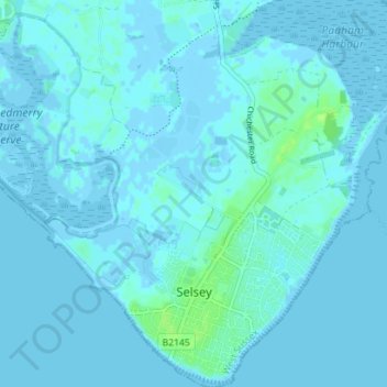
Nombre: Mapa topográfico Selsey, altitud, relieve.
Lugar: Selsey, Chichester, West Sussex, England, United Kingdom (50.72178 -0.81895 50.76629 -0.74938)
Altitud media: 1 m
Altitud mínima: -4 m
Altitud máxima: 9 m
Otros mapas topográficos
Haga clic en un mapa para ver su topografía, su altitud y su relieve.
Blackdown
United Kingdom > England > West Sussex > Chichester
Blackdown, or Black Down, summit elevation 279.7 metres (918 ft) AMSL, is the highest point in both the historic county of Sussex and the South Downs National Park. It is one of the highest points in the south east of England, exceeded by Walbury Hill, Leith Hill and Pilot Hill. Blackdown is protected as part…
Altitud media: 165 m