
Mapa topográfico Riedholz
Mapa interactivo
Haga clic en el mapa para ver la altitud.
Acerca de este mapa
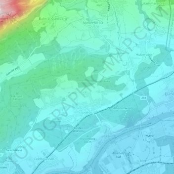
Nombre: Mapa topográfico Riedholz, altitud, relieve.
Altitud media: 532 m
Altitud mínima: 418 m
Altitud máxima: 1.253 m
Otros mapas topográficos
Haga clic en un mapa para ver su topografía, su altitud y su relieve.
Günsberg
Schweiz > Solothurn > Amtei Solothurn-Lebern
Günsberg, Bezirk Lebern, Amtei Solothurn-Lebern, Solothurn, 4524, Schweiz
Altitud media: 785 m
Bellach
Schweiz > Solothurn > Amtei Solothurn-Lebern
Bellach, Bezirk Lebern, Amtei Solothurn-Lebern, Solothurn, 4512, Schweiz
Altitud media: 457 m
Oberdorf (SO)
Schweiz > Solothurn > Amtei Solothurn-Lebern
Oberdorf (SO), Bezirk Lebern, Amtei Solothurn-Lebern, Solothurn, 4515, Schweiz
Altitud media: 805 m
Lommiswil
Schweiz > Solothurn > Amtei Solothurn-Lebern > Lommiswil
Lommiswil, Bezirk Lebern, Amtei Solothurn-Lebern, Solothurn, 4514, Schweiz
Altitud media: 749 m
Grenchen
Schweiz > Solothurn > Amtei Solothurn-Lebern
Grenchen, Bezirk Lebern, Amtei Solothurn-Lebern, Solothurn, 2540, Schweiz
Altitud media: 705 m
Balm bei Günsberg
Schweiz > Solothurn > Amtei Solothurn-Lebern
Balm bei Günsberg, Bezirk Lebern, Amtei Solothurn-Lebern, Solothurn, 4525, Schweiz
Altitud media: 834 m