
Mapa topográfico Coleford
Mapa interactivo
Haga clic en el mapa para ver la altitud.
Acerca de este mapa
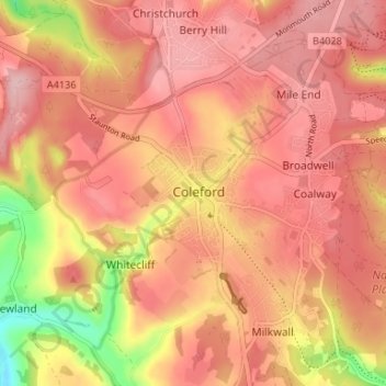
Nombre: Mapa topográfico Coleford, altitud, relieve.
Altitud media: 193 m
Altitud mínima: 82 m
Altitud máxima: 243 m
Otros mapas topográficos
Haga clic en un mapa para ver su topografía, su altitud y su relieve.
Upper Soudley
United Kingdom > England > Gloucestershire > Forest of Dean
Upper Soudley, Forest of Dean, Gloucestershire, England, GL14 2TS, United Kingdom
Altitud media: 138 m
St. Briavels
United Kingdom > England > Gloucestershire > Forest of Dean
St. Briavels, Forest of Dean, Gloucestershire, England, United Kingdom
Altitud media: 147 m
Aylburton
United Kingdom > England > Gloucestershire > Forest of Dean > Aylburton
Aylburton, Forest of Dean, Gloucestershire, England, United Kingdom
Altitud media: 37 m