
Mapa topográfico Calingasta
Mapa interactivo
Haga clic en el mapa para ver la altitud.
Acerca de este mapa
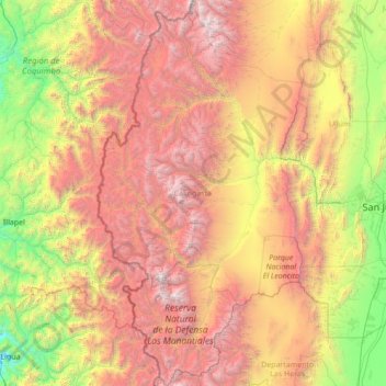
Nombre: Mapa topográfico Calingasta, altitud, relieve.
Lugar: Calingasta, San Juan, Argentina (-32.62663 -70.56968 -30.26862 -69.10017)
Altitud media: 2.393 m
Altitud mínima: 74 m
Altitud máxima: 6.583 m
Calingasta has a rugged, hilly topography due to its location is at the foot of the Andes. The mountain Mercedario is the eighth-highest mountain of the Andes with an altitude of 6,720 metres (22,050 ft). It is located 100 kilometres (62 mi) north of Aconcagua. It is possible to highlight an area precordillerana lower height as the first with numerous mountain cave highlight the Sierra del Tontal. The soil is mainly desert with little vegetation cover except on the river banks in the valleys.
Otros mapas topográficos
Haga clic en un mapa para ver su topografía, su altitud y su relieve.
Villa San Andrés
Villa San Andrés, Capital, San Juan, Argentina
Altitud media: 661 m
Ischigualasto Provincial Park
Ischigualasto Provincial Park, Valle Fértil, San Juan, Argentina
Altitud media: 1.258 m
Hediondo (o Rincón del Diablo)
Hediondo (o Rincón del Diablo), Iglesia, San Juan, Argentina
Altitud media: 4.025 m
Parkinson Hill
Parkinson Hill, Zonda, San Juan, 5478, Argentina
Altitud media: 1.336 m
Quebrada Seca
Quebrada Seca, Calingasta, San Juan, Argentina
Altitud media: 3.106 m
Cerro Mercedario
Cerro Mercedario, Calingasta, San Juan, Argentina
Altitud media: 6.128 m