
Mapa topográfico Mount Warren
Mapa interactivo
Haga clic en el mapa para ver la altitud.
Acerca de este mapa
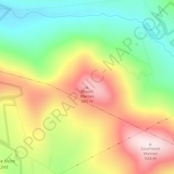
Nombre: Mapa topográfico Mount Warren, altitud, relieve.
Lugar: Mount Warren, Town of Bovina, Delaware County, New York, USA (42.31476 -74.70465 42.31486 -74.70455)
Altitud media: 677 m
Altitud mínima: 479 m
Altitud máxima: 913 m
Otros mapas topográficos
Haga clic en un mapa para ver su topografía, su altitud y su relieve.
Staten Island
Staten Island, Richmond County, New York, USA
Altitud media: 11 m
East Maine
USA > New York > East Maine
East Maine, Maine Town, Broome County, New York, USA
Altitud media: 433 m
Buchanan
USA > New York > Buchanan > Town of Cortlandt
Buchanan, Town of Cortlandt, Westchester County, New York, 10511, USA
Altitud media: 27 m
Livingston Island
Livingston Island, Town of Philipstown, Putnam County, New York, 10922, USA
Altitud media: 156 m
Falls Creek
Falls Creek, Town of Delhi, Delaware County, New York, 13753, USA
Altitud media: 515 m
Flat Top Mountain
Flat Top Mountain, Franklin County, New York, USA
Altitud media: 568 m
Avalanche Lake
Avalanche Lake, Avalanche Pass Trail, Essex County, New York, USA
Altitud media: 1.066 m
Big Bear Mountain
Big Bear Mountain, Town of Johnsburg, Warren County, New York, USA
Altitud media: 616 m