
Mapa topográfico Post Falls
Mapa interactivo
Haga clic en el mapa para ver la altitud.
Acerca de este mapa
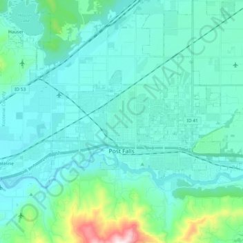
Nombre: Mapa topográfico Post Falls, altitud, relieve.
Lugar: Post Falls, Kootenai County, Idaho, 83854, United States (47.69255 -117.04179 47.75945 -116.85641)
Altitud media: 710 m
Altitud mínima: 619 m
Altitud máxima: 1.295 m
Post Falls is located on the Rathdrum Prairie, along the Washington–Idaho border. It is bounded by Coeur d’Alene to the east, Stateline and the state of Washington to the west, and the Spokane River to the south. Post Falls is 20 miles (32 km) east of Spokane and approximately 100 miles (160 km) south of the Canada–United States border. The elevation of the city is 2,182 feet (665 m) above sea level.
Otros mapas topográficos
Haga clic en un mapa para ver su topografía, su altitud y su relieve.
Coeur d'Alene
United States > Idaho > Kootenai County
Coeur d'Alene, Kootenai County, Idaho, United States
Altitud media: 719 m
Bayview
United States > Idaho > Kootenai County
Bayview, Kootenai County, Idaho, United States
Altitud media: 733 m
Athol
United States > Idaho > Kootenai County
Athol, Kootenai County, Idaho, United States
Altitud media: 733 m
Hayden
United States > Idaho > Kootenai County
Hayden, Kootenai County, Idaho, 83835, United States
Altitud media: 717 m
Rathdrum
United States > Idaho > Kootenai County
Rathdrum, Kootenai County, Idaho, 83858, United States
Altitud media: 701 m