
Mapa topográfico San Rafael
Mapa interactivo
Haga clic en el mapa para ver la altitud.
Acerca de este mapa
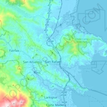
Nombre: Mapa topográfico San Rafael, altitud, relieve.
Altitud media: 78 m
Altitud mínima: -6 m
Altitud máxima: 778 m
San Rafael has a wide diversity of natural habitats from forests at the higher elevations to marshland and estuarine settings. Its marshes are home to the endangered species Salt Marsh Harvest Mouse. There are also riparian areas including the San Rafael Creek and Miller Creek corridors.