
Mapa topográfico Gloucester
Mapa interactivo
Haga clic en el mapa para ver la altitud.
Acerca de este mapa
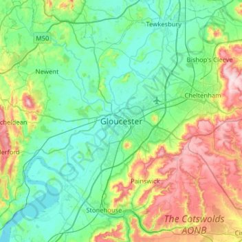
Nombre: Mapa topográfico Gloucester, altitud, relieve.
Altitud media: 83 m
Altitud mínima: -2 m
Altitud máxima: 329 m
Otros mapas topográficos
Haga clic en un mapa para ver su topografía, su altitud y su relieve.
White City
United Kingdom > England > Gloucestershire > Gloucester
White City, Gloucester, Gloucestershire, England, GL4 6UL, United Kingdom
Altitud media: 38 m
Lower Rea
United Kingdom > England > Gloucestershire > Gloucester
Lower Rea, Quedgeley, Gloucester, Gloucestershire, England, GL2 3NW, United Kingdom
Altitud media: 17 m