
Haz una donación
Equípate para tu próxima aventura:
Como asociado de Amazon, este sitio gana comisiones por las compras que califican, sin ningún costo adicional para usted.
Mapa topográfico Batasan Hills
Haga clic en el mapa para ver la altitud.
Haz una donación
Equípate para tu próxima aventura:
Como asociado de Amazon, este sitio gana comisiones por las compras que califican, sin ningún costo adicional para usted.
Acerca de este mapa
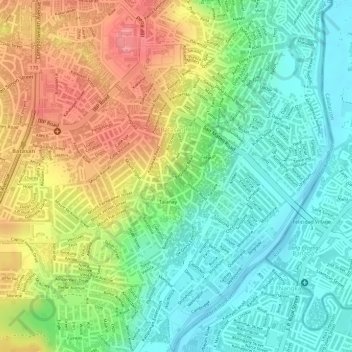
Nombre: Mapa topográfico Batasan Hills, altitud, relieve.
Altitud media: 49 m
Altitud mínima: 5 m
Altitud máxima: 108 m
Haz una donación
Equípate para tu próxima aventura:
Como asociado de Amazon, este sitio gana comisiones por las compras que califican, sin ningún costo adicional para usted.
Otros mapas topográficos
Haga clic en un mapa para ver su topografía, su altitud y su relieve.
La Mesa Eco Park
Covering an area of 33 hectares (82 acres) the public park is located along the natural boundary of the La Mesa Watershed Reservation and its elevation is about 40 metres (130 ft) below than the resorvoir.
Altitud media: 66 m
Haz una donación
Equípate para tu próxima aventura:
Como asociado de Amazon, este sitio gana comisiones por las compras que califican, sin ningún costo adicional para usted.
La Mesa Dam
The La Mesa was built in Novaliches, which was then still part of the municipality of Caloocan due to the sloping topography of the watershed area from Bulacan. The La Mesa dam later became part of a larger dam system with the opening of the Ipo Dam in Norzagaray, Bulacan in 1936, the Angat Dam in the same…
Altitud media: 65 m
Haz una donación
Equípate para tu próxima aventura:
Como asociado de Amazon, este sitio gana comisiones por las compras que califican, sin ningún costo adicional para usted.
Haz una donación
Equípate para tu próxima aventura:
Como asociado de Amazon, este sitio gana comisiones por las compras que califican, sin ningún costo adicional para usted.
Haz una donación
Equípate para tu próxima aventura:
Como asociado de Amazon, este sitio gana comisiones por las compras que califican, sin ningún costo adicional para usted.
La Mesa Dam
The La Mesa was built in Novaliches, which was then still part of the municipality of Caloocan due to the sloping topography of the watershed area from Bulacan. The La Mesa dam later became part of a larger dam system with the opening of the Ipo Dam in Norzagaray, Bulacan in 1936, the Angat Dam in the same…
Altitud media: 65 m
Haz una donación
Equípate para tu próxima aventura:
Como asociado de Amazon, este sitio gana comisiones por las compras que califican, sin ningún costo adicional para usted.