
Mapa topográfico Osage County
Mapa interactivo
Haga clic en el mapa para ver la altitud.
Acerca de este mapa
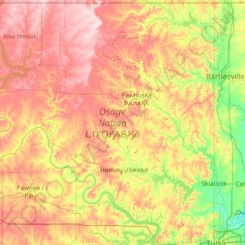
Nombre: Mapa topográfico Osage County, altitud, relieve.
Lugar: Osage County, Oklahoma, United States (36.16079 -97.06701 36.99929 -96.00046)
Altitud media: 277 m
Altitud mínima: 175 m
Altitud máxima: 413 m
Holmes Peak is a mountain northwest of Tulsa in Osage County. It was named by the United States Board on Geographic Names on October 5, 1983 for the fictional detective, Sherlock Holmes. The name was proposed by Richard S. Warner. Holmes Peak is the highest point in the Tulsa Metropolitan area, with an elevation of 1,030 feet (310 m), though it ranks only as the 379th highest point in the state.
Otros mapas topográficos
Haga clic en un mapa para ver su topografía, su altitud y su relieve.
Skiatook
United States > Oklahoma > Osage County
Skiatook, Osage County, Oklahoma, 74070, United States
Altitud media: 222 m
Foraker
United States > Oklahoma > Osage County
Foraker, Osage County, Oklahoma, United States
Altitud media: 385 m
Fairfax
United States > Oklahoma > Osage County
Fairfax, Osage County, Oklahoma, United States
Altitud media: 259 m
Herd
United States > Oklahoma > Osage County
Herd, Osage County, Oklahoma, United States
Altitud media: 287 m