
Haz una donación
Equípate para tu próxima aventura:
Como asociado de Amazon, este sitio gana comisiones por las compras que califican, sin ningún costo adicional para usted.
Mapa topográfico Cambridge
Haga clic en el mapa para ver la altitud.
Haz una donación
Equípate para tu próxima aventura:
Como asociado de Amazon, este sitio gana comisiones por las compras que califican, sin ningún costo adicional para usted.
Cambridge
Cambridge obtains water from Hobbs Brook (in Lincoln and Waltham) and Stony Brook (Waltham and Weston), as well as an emergency connection to the Massachusetts Water Resources Authority. The city owns over 1,200 acres (486 ha) of land in other towns that includes these reservoirs and portions of their watershed. Water from these reservoirs flows by gravity through an aqueduct to Fresh Pond in Cambridge. It is then treated in an adjacent plant and pumped uphill to an elevation of 176 feet (54 m) above sea level at the Payson Park Reservoir (Belmont). The water is then redistributed downhill via gravity to individual users in the city. A new water treatment plant opened in 2001.
Haz una donación
Equípate para tu próxima aventura:
Como asociado de Amazon, este sitio gana comisiones por las compras que califican, sin ningún costo adicional para usted.
Acerca de este mapa
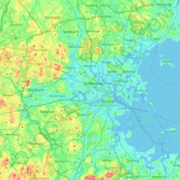
Nombre: Mapa topográfico Cambridge, altitud, relieve.
Altitud media: 31 m
Altitud mínima: -5 m
Altitud máxima: 152 m
Haz una donación
Equípate para tu próxima aventura:
Como asociado de Amazon, este sitio gana comisiones por las compras que califican, sin ningún costo adicional para usted.