
Haz una donación
Equípate para tu próxima aventura:
Como asociado de Amazon, este sitio gana comisiones por las compras que califican, sin ningún costo adicional para usted.
Mapa topográfico Boulder Creek
Haga clic en el mapa para ver la altitud.
Haz una donación
Equípate para tu próxima aventura:
Como asociado de Amazon, este sitio gana comisiones por las compras que califican, sin ningún costo adicional para usted.
Boulder Creek
Boulder Creek sits at the north end of the San Lorenzo Valley at the confluence of San Lorenzo River and Boulder Creek within the Santa Cruz Mountains, a Level IV ecoregion designated by the United States Environmental Protection Agency (EPA), an area surrounded by steep, redwood- and pine- covered hills formed by the river, creek, and their tributaries. The river flows through Boulder Creek on the east and south through Brookdale, Ben Lomond, and Felton, and continues south to the City of Santa Cruz where it enters Monterey Bay. Directly across from Boulder Creek's confluence with the San Lorenzo River, Bear Creek flows into the river and creates a topographical feature known as the Turkey Foot. The Turkey Foot creates a floodplain, particularly on the western side of the river where the mountainside is less steep.
Haz una donación
Equípate para tu próxima aventura:
Como asociado de Amazon, este sitio gana comisiones por las compras que califican, sin ningún costo adicional para usted.
Acerca de este mapa
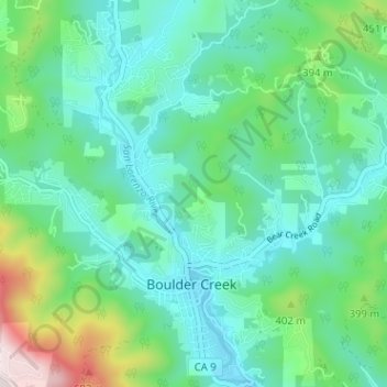
Nombre: Mapa topográfico Boulder Creek, altitud, relieve.
Altitud media: 287 m
Altitud mínima: 136 m
Altitud máxima: 799 m
Haz una donación
Equípate para tu próxima aventura:
Como asociado de Amazon, este sitio gana comisiones por las compras que califican, sin ningún costo adicional para usted.