
Mapa topográfico Potenza
Mapa interactivo
Haga clic en el mapa para ver la altitud.
Acerca de este mapa
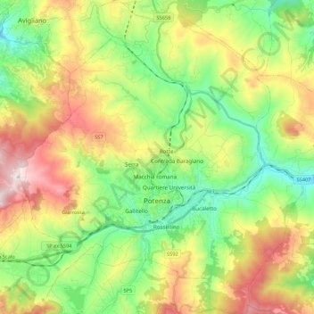
Nombre: Mapa topográfico Potenza, altitud, relieve.
Lugar: Potenza, Basilicata, Italy (40.58025 15.70628 40.74174 15.90302)
Altitud media: 872 m
Altitud mínima: 574 m
Altitud máxima: 1.347 m
The first settlement of Potentia (Potenza's original Latin name) was probably located at a lower elevation than at present, some 10 kilometres (6 miles) south of today's Potenza. The Lucani of Potentia sided against Rome's enemies during the latter's wars against the Samnites and the Bruttii. Subjugated during the 4th century BC (later gaining the status of municipium), the Potentini rebelled after the Roman defeat at Cannae in 216 BC. However, the Battle of the Metaurus marked the end of any Carthaginian aspirations in Italy and Potentia was reconquered by the Romans and reduced to the status of military colony.
Otros mapas topográficos
Haga clic en un mapa para ver su topografía, su altitud y su relieve.
Castelsaraceno
Italy > Basilicata > Potenza
Castelsaraceno, Potenza, Basilicata, Italy
Altitud media: 1.104 m
Viadotto Pantanelle
Italy > Basilicata > Potenza > Nemoli
Viadotto Pantanelle, Nemoli, Potenza, Basilicata, Italy
Altitud media: 1.685 m
Porco Morto
Italy > Basilicata > Potenza > Picerno > Porco Morto
Porco Morto, Picerno, Potenza, Basilicata, Italy
Altitud media: 1.071 m
Balvano
Italy > Basilicata > Potenza > Balvano
Balvano, Potenza, Basilicata, Italy
Altitud media: 621 m