
Mapa topográfico Tangmere
Haga clic en el mapa para ver la altitud.
Acerca de este mapa
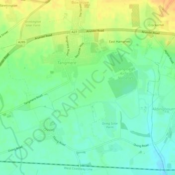
Nombre: Mapa topográfico Tangmere, altitud, relieve.
Lugar: Tangmere, Chichester, West Sussex, England, United Kingdom (50.83507 -0.73486 50.85554 -0.68613)
Altitud media: 14 m
Altitud mínima: -2 m
Altitud máxima: 35 m
Otros mapas topográficos
Haga clic en un mapa para ver su topografía, su altitud y su relieve.
Blackdown
United Kingdom > England > West Sussex > Chichester
Blackdown, or Black Down, summit elevation 279.7 metres (918 ft) AMSL, is the highest point in both the historic county of Sussex and the South Downs National Park. It is one of the highest points in the south east of England, exceeded by Walbury Hill, Leith Hill and Pilot Hill. Blackdown is protected as part…
Altitud media: 165 m